"6b09b40477bc408d"{"id":"1002739","slug":"desert-embankments-photoscan-vol-4","title":"Desert Embankments - Photoscan Vol 4.","category":"Terrain","engine":"5.0+","assetVersion":"","engineVersion":"Engine Version: 5.0+","tag":"Terrain","accent":"blue","visual":"mech","summary":"Examine Desert Embankments - Photoscan Vol 4, featuring 4K photogrammetry meshes, Quixel-matched density, arid foliage, and advanced master materials.","platform":"Unreal Engine","indexPolicy":"index","publishedAt":"2026-11-19T02:44:26.139Z","updatedAt":"2026-11-19T02:44:26.139Z","sourceNotes":[],"fileContents":[],"compatibility":["Unreal Engine","Engine Version: 5.0+"],"featuredImage":{"alt":"Desert Embankments - Photoscan Vol 4.","src":"/wp-content/uploads/published/2026/11/b3989f43e0ec-e8430061-6faf-4bc4-affb-6899d4982a28-47ff30cbb6.webp"},"hasDownloadLink":true,"downloads":0,"terms":[{"taxonomy":"category","slug":"terrain","name":"Terrain"}],"galleryImages":[{"src":"/wp-content/uploads/published/2026/11/dbb7c60581a9-7a9537f7-cdbc-40ee-b704-4e722b0b1dde-aa18aeec18.webp","alt":"Desert Embankments - Photoscan Vol 4."},{"src":"/wp-content/uploads/published/2026/11/9993021ecd08-638a956a-0cef-4410-9838-9b6948b7dcc8-d30674271b.webp","alt":"Desert Embankments - Photoscan Vol 4."},{"src":"/wp-content/uploads/published/2026/11/ca0e3ff955b4-1f7c7dea-d49b-48dd-bd91-1b03f9dbfabc-19ccdeeab4.webp","alt":"Desert Embankments - Photoscan Vol 4."},{"src":"/wp-content/uploads/published/2026/11/e1c51ba344aa-de6d5ab7-8202-420c-bbc8-e3c0973b4a04-64eb3e6774.webp","alt":"Desert Embankments - Photoscan Vol 4."},{"src":"/wp-content/uploads/published/2026/11/1bafdfb42007-ea01db8c-8bde-4b5c-b2d5-5ec89a1b9d8a-2b2ec5ec28.webp","alt":"Desert Embankments - Photoscan Vol 4."},{"src":"/wp-content/uploads/published/2026/11/8318fca7473b-249a0d07-9584-4796-b860-ccac01c1a5dc-24ef3482fc.webp","alt":"Desert Embankments - Photoscan Vol 4."},{"src":"/wp-content/uploads/published/2026/11/24468024471c-d0568711-c737-4bf3-b644-243029bd6970-86c2515e9a.webp","alt":"Desert Embankments - Photoscan Vol 4."},{"src":"/wp-content/uploads/published/2026/11/eaa1e733180f-3a75e773-5224-44bd-8a24-d9dd97ccb53f-0fec54c84d.webp","alt":"Desert Embankments - Photoscan Vol 4."},{"src":"/wp-content/uploads/published/2026/11/7b51a52577da-6b320887-c253-4eb1-81ef-9344adc7e538-7f230d3ae3.webp","alt":"Desert Embankments - Photoscan Vol 4."},{"src":"/wp-content/uploads/published/2026/11/32a2cfa809c2-01906e63-19e6-4ae8-8cad-bf9b755c40ef-329b0baac4.webp","alt":"Desert Embankments - Photoscan Vol 4."}],"accessPanel":{"kind":"resource","title":"Get this resource","safetyNote":"Resources are manually reviewed before listing to improve quality and reduce obvious risks.","fileName":"Content.7z","resourceType":"Resource archive","versions":[]},"contentHtml":"\u003cp\u003eConstructing believable natural transitions between flat terrain and vertical topography requires geometry that reflects real-world geological erosion. Desert Embankments - Photoscan Vol 4 provides a focused set of five photogrammetric embankment meshes captured from Australian arid landscapes. Rather than presenting generic digital sculpts, these assets reproduce the distinct, sun-baked clay, fractured rock faces, and sediment deposits characteristic of Australian desert cliffs and washes.\u003c/p\u003e \u003ch2\u003eIntegrating Desert Embankments into Terrain and Level Layouts\u003c/h2\u003e\n\u003cp\u003eThe core of the package consists of five distinct desert embankments built as open meshes. In environment production, open meshes provide distinct practical advantages when shaping topography. Because they lack back-facing geometry or closed under-surfaces, level designers can embed them straight into landscape heightmaps, sand banks, or rock outcroppings without wasting memory or polygon budgets on unseen polys. They function effectively as retaining formations, gullies, washed-out riverbanks, or eroded borders along dry tracks.\u003c/p\u003e \u003cp\u003eThese models are configured to serve dual production purposes. They come optimized directly for runtime game environments, balancing performance while retaining crisp silhouette fidelity across uneven ridge lines. When projects require higher geometric precision—such as film sequences, cinematics, or high-end architectural visualization—the meshes support tessellation. Activating tessellation transforms the optimized game meshes into cinematic hero-quality surfaces, displacing real geometric depth along every crack, furrow, and natural shelf present in the original scan data.\u003c/p\u003e \u003ch2\u003eMegascans Density Calibration across Desert Embankments Geometry\u003c/h2\u003e\n\u003cp\u003eA frequent challenge when integrating third-party photogrammetry into modern pipelines is visual disparity between different asset libraries. Discrepancies in triangle distribution and texel density can cause one mesh to appear noticeably blurrier or sharper than its neighbor. To eliminate this issue, every effort was made to calibrate both the triangle density and texel density of these models directly against Megascans standards. As a result, the embankments sit naturally alongside Quixel assets in the same viewport without requiring manual UV scaling or mesh retopology passes.\u003c/p\u003e \u003cp\u003eThe texture pipeline reflects the same rigor. Initial scan captures were processed at 8K resolution and downscaled to 4K for engine implementation. This supersampled capture workflow ensures that minute micro-surface features—such as grit, baked dirt striations, and fine mineral deposits—remain exceptionally crisp without causing mipmap artifacts. Where suitable for memory management, the textures use channel packing, combining ambient occlusion and roughness maps into single texture channels to streamline texture sampler calls during rendering.\u003c/p\u003e \u003ch2\u003eSurface Blending with the Core Desert Embankments Master Material\u003c/h2\u003e\n\u003cp\u003ePhotogrammetric cliffs often suffer from hard, unnatural contact seams when intersected with terrain meshes. To solve this blending issue, the collection includes a master material equipped with pixel-depth offset. Enabling pixel-depth offset dithers the mesh intersection against landscape terrain, softening hard cut lines into gradual, natural transitions that look like accumulated dust and dirt against the base of the formation.\u003c/p\u003e \u003cp\u003eThe master material also incorporates dedicated tessellation options to drive displacement directly in the viewport. Surface appearance is fully customizable through exposed parameters controlling roughness levels and surface tinting. For deeper shadow response in dynamic lighting scenarios, artists can use the built-in control to multiply ambient occlusion into the albedo channel. Detail mapping controls are also exposed within the material graph, allowing teams to inject fine tiling micro-normal data that maintains close-up visual fidelity when the camera approaches directly against the rock face.\u003c/p\u003e \u003ch2\u003eGround Scatter and Atlas Variations in Photoscan Vol 4\u003c/h2\u003e\n\u003cp\u003eLarge geological structures rarely exist in isolation; they are naturally surrounded by broken scree and dried plant detritus. Desert Embankments - Photoscan Vol 4 supplies eight bonus photogrammetric texture atlas variations complete with matching meshes that are pre-assembled and ready for scene placement. These bonus scatter elements divide evenly into plant matter and broken geological debris:\u003c/p\u003e \u003cul\u003e \u003cli\u003eDry Grass Pile 01\u003c/li\u003e \u003cli\u003eDry Grass Pile 02\u003c/li\u003e \u003cli\u003eDry Grass Pile 03\u003c/li\u003e \u003cli\u003eDry Grass Pile 04\u003c/li\u003e \u003cli\u003eDesert Rock Pile 01\u003c/li\u003e \u003cli\u003eDesert Rock Pile 02\u003c/li\u003e \u003cli\u003eDesert Rock Pile 03\u003c/li\u003e \u003cli\u003eDesert Rock Pile 04\u003c/li\u003e\n\u003c/ul\u003e \u003cp\u003ePlacing these rock and grass piles along the bottom contact lines and upper edges of the open meshes breaks up repeated geometry and integrates the large structures into the broader ground plane.\u003c/p\u003e \u003ch2\u003eMatching Arid Foliage and Continuing Biome Consistency\u003c/h2\u003e\n\u003cp\u003eTo reinforce biome cohesion, the package includes seven arid weed variations sourced directly from the exact same environment where the main embankments were scanned. Because the lighting conditions, native soil tint, and botanical species match the cliff geometry, the plants blend seamlessly without needing color-grading adjustments.\u003c/p\u003e \u003cp\u003eThe weed collection provides a full spread of growth cycles and debris states:\u003c/p\u003e \u003cul\u003e \u003cli\u003eArid Weed Mature 01 and 02 for upright, full-grown shrub accents\u003c/li\u003e \u003cli\u003eArid Weed Juvenile 01 and 02 for younger, sparse scrub growth\u003c/li\u003e \u003cli\u003eArid Weed Litter 01, 02, 03, and 04 for fallen, dead organic scatter nestled along banks\u003c/li\u003e\n\u003c/ul\u003e \u003cp\u003eAn additional foliage master material is provided specifically for these texture atlas elements. It features exposed parameters to quickly adjust values, ensuring the vegetation can be tweaked to match lighting setups across different scenes. This release forms part of a wider series depicting Australian environments, fitting directly beside companion packs such as Vol 1. Termite Mounds, Vol 2. Dry Animal Bones, and Vol 3. Animal Dung, all of which belong to the overarching Australian Desert Collection.\u003c/p\u003e\n\n\u003ch2\u003eContinue Browsing Similar Packs\u003c/h2\u003e\n\u003cul\u003e\n\u003cli\u003e\u003ca href=\"https://3dcghub.com/dry-animal-bones-photoscan-vol-2/\" rel=\"noopener noreferrer\"\u003eDry Animal Bones - Photoscan Vol 2.\u003c/a\u003e\u003c/li\u003e\n\u003cli\u003e\u003ca href=\"https://3dcghub.com/sand-vol-40-hand-painted-textures/\" rel=\"noopener noreferrer\"\u003eSand Vol.40 - Hand Painted Textures\u003c/a\u003e\u003c/li\u003e\n\u003cli\u003e\u003ca href=\"https://3dcghub.com/terrain-models-pack-vol-3/\" rel=\"noopener noreferrer\"\u003eTerrain Models Pack Vol. 3\u003c/a\u003e\u003c/li\u003e\n\u003cli\u003e\u003ca href=\"https://3dcghub.com/australian-desert-photoscan-collection/\" rel=\"noopener noreferrer\"\u003eAustralian Desert Photoscan Collection\u003c/a\u003e\u003c/li\u003e\n\u003cli\u003e\u003ca href=\"https://3dcghub.com/animal-dung-feces-horse-and-cow-photoscan-vol-3/\" rel=\"noopener noreferrer\"\u003eAnimal Dung/Feces - Horse and Cow - Photoscan Vol 3.\u003c/a\u003e\u003c/li\u003e\n\u003c/ul\u003e","contentTextLength":6211,"navigation":{"current":3,"total":4663,"previous":{"id":"1002740","slug":"underwater-world-70-assets","title":"Underwater World / 70 Assets","category":"Aquatic","platform":"Unreal Engine","updatedAt":"2026-11-19T02:45:41.177Z"},"next":{"id":"1002285","slug":"eduquill-for-unreal-engine","title":"EduQuill for Unreal Engine – Safe Imports and Project Health Toolkit (UE 5.4–5.8)","category":"Engine Tools","platform":"Unreal Engine","updatedAt":"2026-11-18T19:00:44.375Z"}},"relatedResources":[{"id":"1002628","slug":"dry-animal-bones-photoscan-vol-2","title":"Dry Animal Bones - Photoscan Vol 2.","category":"Nature \u0026 Plants","engine":"5.0+","assetVersion":"","engineVersion":"Engine Version: 5.0+","tag":"Nature \u0026 Plants","accent":"blue","visual":"mech","summary":"Examine Dry Animal Bones - Photoscan Vol 2, featuring 12 complete 4k bone meshes and 5 Australian desert ground materials optimized for games and cinematics.","platform":"Unreal Engine","indexPolicy":"index","publishedAt":"2026-11-15T06:07:04.009Z","updatedAt":"2026-11-15T06:07:04.009Z","sourceNotes":[],"fileContents":[],"compatibility":["Unreal Engine","Engine Version: 5.0+"],"featuredImage":{"alt":"Dry Animal Bones - Photoscan Vol 2.","src":"/wp-content/uploads/published/2026/11/0f13139086fc-301c9738-a161-404a-91af-46495867f383-a25d881d35.webp"},"fileSizeBytes":1448922307,"hasDownloadLink":true,"downloads":0},{"id":"1001907","slug":"sand-vol-40-hand-painted-textures","title":"Sand Vol.40 - Hand Painted Textures","category":"Nature \u0026 Terrain","engine":"4.22+,5.0+","assetVersion":"","engineVersion":"Engine Version: 4.22+,5.0+","tag":"Nature \u0026 Terrain","accent":"blue","visual":"luts","summary":"Examine Sand Vol.40 - Hand Painted Textures, featuring 7 tillable 2048px PBR surfaces designed for stylized deserts, rocky grit, and fantasy environments.","platform":"Unreal Engine","indexPolicy":"index","publishedAt":"2026-10-22T11:45:22.411Z","updatedAt":"2026-10-22T11:45:22.411Z","sourceNotes":[],"fileContents":[],"compatibility":["Unreal Engine","Engine Version: 4.22+,5.0+"],"featuredImage":{"alt":"Sand Vol.40 - Hand Painted Textures","src":"/wp-content/uploads/published/2026/10/1da18eae57da-85e5c46c-0333-4304-94ba-a4edf0bbbb9d-8949436dd0.webp"},"fileSizeBytes":130052385,"hasDownloadLink":true,"downloads":1},{"id":"1002231","slug":"terrain-models-pack-vol-3","title":"Terrain Models Pack Vol. 3","category":"Nature \u0026 Plants","engine":"5.3+","assetVersion":"","engineVersion":"Engine Version: 5.3+","tag":"Nature \u0026 Plants","accent":"blue","visual":"mech","summary":"Explore Terrain Models Pack Vol. 3, featuring five high quality terrains including snow mountains, valleys, deserts, and alien planets with 4 to 5 models each.","platform":"Unreal Engine","indexPolicy":"index","publishedAt":"2026-10-29T15:34:00.934Z","updatedAt":"2026-10-29T15:34:00.934Z","sourceNotes":[],"fileContents":[],"compatibility":["Unreal Engine","Engine Version: 5.3+"],"featuredImage":{"alt":"Terrain Models Pack Vol. 3","src":"/wp-content/uploads/published/2026/10/02620cb20698-14b442c0-32c7-4581-9674-3a9bccf99c11-ae20ebcd30.webp"},"fileSizeBytes":5865826918,"hasDownloadLink":true,"downloads":1}]}
Resource screenshots
1 / 10
Join our channel
Follow 3DCGHUB on Telegram for new resource drops, migration updates, and community notices.
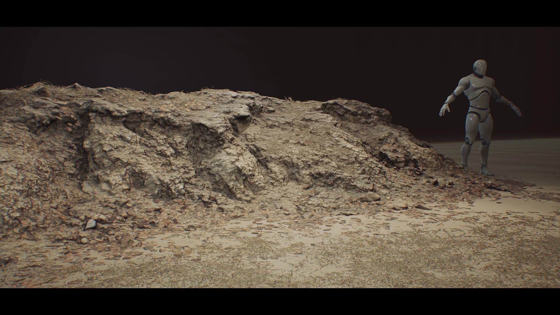
Constructing believable natural transitions between flat terrain and vertical topography requires geometry that reflects real-world geological erosion. Desert Embankments - Photoscan Vol 4 provides a focused set of five photogrammetric embankment meshes captured from Australian arid landscapes. Rather than presenting generic digital sculpts, these assets reproduce the distinct, sun-baked clay, fractured rock faces, and sediment deposits characteristic of Australian desert cliffs and washes.
Integrating Desert Embankments into Terrain and Level Layouts
The core of the package consists of five distinct desert embankments built as open meshes. In environment production, open meshes provide distinct practical advantages when shaping topography. Because they lack back-facing geometry or closed under-surfaces, level designers can embed them straight into landscape heightmaps, sand banks, or rock outcroppings without wasting memory or polygon budgets on unseen polys. They function effectively as retaining formations, gullies, washed-out riverbanks, or eroded borders along dry tracks.
These models are configured to serve dual production purposes. They come optimized directly for runtime game environments, balancing performance while retaining crisp silhouette fidelity across uneven ridge lines. When projects require higher geometric precision—such as film sequences, cinematics, or high-end architectural visualization—the meshes support tessellation. Activating tessellation transforms the optimized game meshes into cinematic hero-quality surfaces, displacing real geometric depth along every crack, furrow, and natural shelf present in the original scan data.
Megascans Density Calibration across Desert Embankments Geometry
A frequent challenge when integrating third-party photogrammetry into modern pipelines is visual disparity between different asset libraries. Discrepancies in triangle distribution and texel density can cause one mesh to appear noticeably blurrier or sharper than its neighbor. To eliminate this issue, every effort was made to calibrate both the triangle density and texel density of these models directly against Megascans standards. As a result, the embankments sit naturally alongside Quixel assets in the same viewport without requiring manual UV scaling or mesh retopology passes.
The texture pipeline reflects the same rigor. Initial scan captures were processed at 8K resolution and downscaled to 4K for engine implementation. This supersampled capture workflow ensures that minute micro-surface features—such as grit, baked dirt striations, and fine mineral deposits—remain exceptionally crisp without causing mipmap artifacts. Where suitable for memory management, the textures use channel packing, combining ambient occlusion and roughness maps into single texture channels to streamline texture sampler calls during rendering.
Surface Blending with the Core Desert Embankments Master Material
Photogrammetric cliffs often suffer from hard, unnatural contact seams when intersected with terrain meshes. To solve this blending issue, the collection includes a master material equipped with pixel-depth offset. Enabling pixel-depth offset dithers the mesh intersection against landscape terrain, softening hard cut lines into gradual, natural transitions that look like accumulated dust and dirt against the base of the formation.
The master material also incorporates dedicated tessellation options to drive displacement directly in the viewport. Surface appearance is fully customizable through exposed parameters controlling roughness levels and surface tinting. For deeper shadow response in dynamic lighting scenarios, artists can use the built-in control to multiply ambient occlusion into the albedo channel. Detail mapping controls are also exposed within the material graph, allowing teams to inject fine tiling micro-normal data that maintains close-up visual fidelity when the camera approaches directly against the rock face.
Ground Scatter and Atlas Variations in Photoscan Vol 4
Large geological structures rarely exist in isolation; they are naturally surrounded by broken scree and dried plant detritus. Desert Embankments - Photoscan Vol 4 supplies eight bonus photogrammetric texture atlas variations complete with matching meshes that are pre-assembled and ready for scene placement. These bonus scatter elements divide evenly into plant matter and broken geological debris:
Dry Grass Pile 01
Dry Grass Pile 02
Dry Grass Pile 03
Dry Grass Pile 04
Desert Rock Pile 01
Desert Rock Pile 02
Desert Rock Pile 03
Desert Rock Pile 04
Placing these rock and grass piles along the bottom contact lines and upper edges of the open meshes breaks up repeated geometry and integrates the large structures into the broader ground plane.
Matching Arid Foliage and Continuing Biome Consistency
To reinforce biome cohesion, the package includes seven arid weed variations sourced directly from the exact same environment where the main embankments were scanned. Because the lighting conditions, native soil tint, and botanical species match the cliff geometry, the plants blend seamlessly without needing color-grading adjustments.
The weed collection provides a full spread of growth cycles and debris states:
Arid Weed Mature 01 and 02 for upright, full-grown shrub accents
Arid Weed Juvenile 01 and 02 for younger, sparse scrub growth
Arid Weed Litter 01, 02, 03, and 04 for fallen, dead organic scatter nestled along banks
An additional foliage master material is provided specifically for these texture atlas elements. It features exposed parameters to quickly adjust values, ensuring the vegetation can be tweaked to match lighting setups across different scenes. This release forms part of a wider series depicting Australian environments, fitting directly beside companion packs such as Vol 1. Termite Mounds, Vol 2. Dry Animal Bones, and Vol 3. Animal Dung, all of which belong to the overarching Australian Desert Collection.
 Nature & Plants
 Nature & Terrain
 Nature & Plants