"322fe79650c29655"{"id":"15285","slug":"landscaping","title":"Landscaping","category":"Procedural Systems","engine":"4.26 - 4.27,5.0 - 5.4","assetVersion":"Engine version: 4.26 - 4.27,5.0 - 5.4","engineVersion":"4.25","tag":"Procedural Systems","accent":"teal","visual":"luts","summary":"Streamline your terrain creation process with Landscaping, a tool designed to import GIS data directly into Unreal Engine. Transform DTMs and satellite imagery into high-fidelity landscapes without external preparation.","platform":"Unreal Engine","publishedAt":"2026-03-12T08:29:46.000Z","updatedAt":"2026-04-19T15:44:51.000Z","sourceNotes":[],"fileContents":[],"compatibility":["Unreal Engine","Engine version: 4.26 - 4.27,5.0 - 5.4"],"featuredImage":{"alt":"Landscaping","src":"https://3dcghub.com/wp-content/uploads/2026/03/9f060901-3780-434e-948f-d12892bf7327.webp"},"hasDownloadLink":true,"pageviews":17,"galleryImages":[{"src":"https://3dcghub.com/wp-content/uploads/2026/03/52a336395487_233c0fab-cc4b-4939-af3b-e3e5bcc34292.webp","alt":"Landscaping"},{"src":"https://3dcghub.com/wp-content/uploads/2026/03/fbbeac562647_78d7128d-c7cc-495b-950d-d1e4e558c379.webp","alt":"Landscaping"},{"src":"https://3dcghub.com/wp-content/uploads/2026/03/4fa7937c93fe_c54c1343-340c-4d41-97cf-e2da86b07ec3.webp","alt":"Landscaping"},{"src":"https://3dcghub.com/wp-content/uploads/2026/03/be55d70ec111_27cd727f-4530-4e42-8c74-1f49dc7dcfb8.webp","alt":"Landscaping"},{"src":"https://3dcghub.com/wp-content/uploads/2026/03/90f53ce2bdc7_4412c89c-6490-4e67-8493-f8d93983e2e1.webp","alt":"Landscaping"},{"src":"https://3dcghub.com/wp-content/uploads/2026/03/1b50e49d705e_debdda92-d91e-41fa-b1e5-6992852bdbe1.webp","alt":"Landscaping"},{"src":"https://3dcghub.com/wp-content/uploads/2026/03/c7d7402065a5_9a583946-cb67-49fd-a7a3-2a6a8faad930.webp","alt":"Landscaping"},{"src":"https://3dcghub.com/wp-content/uploads/2026/03/8f0e015c8cdd_7b2ebbf7-3842-445d-8609-47b164b6b4ef.webp","alt":"Landscaping"},{"src":"https://3dcghub.com/wp-content/uploads/2026/03/e0f01ca31199_115e4d92-35c6-405e-a3d4-eaa69ce5ec67.webp","alt":"Landscaping"},{"src":"https://3dcghub.com/wp-content/uploads/2026/03/6b7c8493855a_5718022c-5a7c-41af-b5de-9a9c72541d3a.webp","alt":"Landscaping"},{"src":"https://3dcghub.com/wp-content/uploads/2026/03/956ed756422e_9ad53b17-32eb-475b-8a35-e9bb78e43586.webp","alt":"Landscaping"},{"src":"https://3dcghub.com/wp-content/uploads/2026/03/163b183834eb_50ae5668-0a87-4724-a18d-21cc35f28584.webp","alt":"Landscaping"},{"src":"https://3dcghub.com/wp-content/uploads/2026/03/3a7f0666d96a_a788ab8c-50b7-4fea-98fd-afe5e557bace.webp","alt":"Landscaping"},{"src":"https://3dcghub.com/wp-content/uploads/2026/03/4c2cc0fa20f8_f428b39e-93cd-4eb3-8383-9dae4c214a7e.webp","alt":"Landscaping"},{"src":"https://3dcghub.com/wp-content/uploads/2026/03/64714e569013_4d5bc8ab-a157-42d7-9e56-77e1141acafd.webp","alt":"Landscaping"},{"src":"https://3dcghub.com/wp-content/uploads/2026/03/d2171b196db7_ccffda3c-b8dd-439b-bd6a-dd3e1b40c2f7.webp","alt":"Landscaping"}],"accessPanel":{"kind":"resource","title":"Access this resource","eyebrow":"Free protected download","message":"Sign in or create an account to continue to the protected download through the managed storage service.","fileName":"Landscaping 4.26-5.4.7z","safetyNote":"All resources are 100% manually reviewed to eliminate all risks.","actionLabel":"Download Free","resourceType":"Resource archive","sourceShortcode":"cryptomus_member"},"contentHtml":"\u003ch2\u003eHigh-Accuracy Terrain Creation with Landscaping\u003c/h2\u003e\n\u003cp\u003eLandscaping provides a streamlined method for importing GIS data into Unreal Engine. This tool allows developers to create single landscapes, World Composition setups in UE4, or World Partition environments in UE5. Furthermore, users can choose to import data as procedural or static meshes depending on project needs.\u003c/p\u003e\n\n\u003cp\u003eThe developer designed this plugin to handle Digital Terrain Models (DTM) with high accuracy. It supports various file formats, including GeoTiff, ASCII, HGT, and GeoPackage. Consequently, users can work with all common projections and resolutions. The system automatically converts single or multiple files into landscapes with appropriate tiling. Additionally, it supports automatic merging and cropping of DTM data for better workflow management.\u003c/p\u003e\n\n\u003ch2\u003eAdvanced Landscape and Mesh Features\u003c/h2\u003e\n\u003cp\u003eLandscaping offers significant flexibility regarding scale and size. It supports landscapes of any area size, limited only by available system memory. Moreover, the tool handles Landscape Edit Layers up to 16 x 16 km per landscape. Users can also create multiple seamless landscapes within a single level. If the source data is low resolution, the plugin provides smoothing options to improve visual quality.\u003c/p\u003e\n\n\u003cp\u003eIntegration of satellite imagery is another core feature. The plugin imports JPG2000 and GeoTiff formats as material textures, decals, or vertex colors. Because the imagery is automatically mapped to the landscape or mesh, the setup process is significantly faster. This ensures that visual data aligns perfectly with the underlying terrain geometry.\u003c/p\u003e\n\n\u003ch2\u003eVector Data and Spline Integration\u003c/h2\u003e\n\u003cp\u003eThe plugin excels at processing vector data from Shapefiles, GeoJSON, OSM, and GeoPackage sources. Landscaping can generate weightmaps to auto-paint landscape layers based on this data. Furthermore, it can instantiate Blueprints, Static Mesh Spline Actors, or Landscape Splines directly from Shapefiles. This functionality allows for the automatic placement of objects or the deformation of landscapes under specific splines.\u003c/p\u003e\n\n\u003cp\u003eOne of the primary benefits is the elimination of external preparation. Users do not need QGIS or other third-party tools to prepare their GIS data. The plugin can read polygons, linestrings, and points via Blueprints. However, it is important to note that the package does not include landscape materials, foliage, or river Blueprints. The developer also notes that this plugin will eventually be retired in favor of the Landscaping System successor.\u003c/p\u003e\n\n\u003ch2\u003eFinal Take\u003c/h2\u003e\n\u003cp\u003eLandscaping is a comprehensive solution for developers needing real-world data integration. It simplifies the transition from raw GIS files to fully realized Unreal Engine environments. By supporting a wide range of formats and offering automated mapping features, it remains a robust choice for terrain generation. Always refer to the official documentation for the latest updates and feature enhancements.\u003c/p\u003e\n\n\u003ch2\u003eContinue Browsing Similar Packs\u003c/h2\u003e\n\u003cul\u003e\n\u003cli\u003e\u003ca href=\"https://3dcghub.com/extile-plus-ultimate-non-tiling-material-toolkit-for-unreal-engine-environments/\" title=\"EXTILE PLUS -Ultimate Non-Tiling Material Toolkit for Unreal Engine Environments\"\u003eEXTILE PLUS -Ultimate Non-Tiling Material Toolkit for Unreal Engine Environments\u003c/a\u003e\u003c/li\u003e\n\u003cli\u003e\u003ca href=\"https://3dcghub.com/ultimate-template-unrealengine-2d-dialogue-inventory-system-save/\" title=\"ULTIMATE Template UnrealEngine || 2D + Dialogue + Inventory system + Save | |\"\u003eULTIMATE Template UnrealEngine || 2D + Dialogue + Inventory system + Save | |\u003c/a\u003e\u003c/li\u003e\n\u003cli\u003e\u003ca href=\"https://3dcghub.com/altermesh-geometry-nodes-in-unreal/\" title=\"AlterMesh – Geometry Nodes in Unreal\"\u003eAlterMesh – Geometry Nodes in Unreal\u003c/a\u003e\u003c/li\u003e\n\u003cli\u003e\u003ca href=\"https://3dcghub.com/zxing-for-unreal/\" title=\"ZXing For Unreal\"\u003eZXing For Unreal\u003c/a\u003e\u003c/li\u003e\n\u003cli\u003e\u003ca href=\"https://3dcghub.com/daz-to-unreal/\" title=\"Daz To Unreal\"\u003eDaz To Unreal\u003c/a\u003e\u003c/li\u003e\n\u003c/ul\u003e\n\n\u003ch2\u003eAsset Gallery\u003c/h2\u003e","contentTextLength":3237,"navigation":{"current":2139,"total":2724,"previous":{"id":"15291","slug":"physical-rope","title":"Physical Rope","category":"Procedural Systems","platform":"Unreal Engine","updatedAt":"2026-04-19T15:44:51.000Z"},"next":{"id":"15315","slug":"procedural-nature-generator","title":"Procedural Nature Generator","category":"Procedural Systems","platform":"Unreal Engine","updatedAt":"2026-04-19T15:44:50.000Z"}},"relatedResources":[{"id":"15225","slug":"crazy-ivy-realistic-ivy-generator-vine-plugin-grow-procedural-plants-in-editor","title":"Crazy Ivy Realistic Ivy Generator Vine Plugin - Grow Procedural Plants in Editor","category":"Procedural Systems","engine":"5.0 - 5.4","assetVersion":"Engine version: 5.0 - 5.4","engineVersion":"4.27","tag":"Procedural Systems","accent":"blue","visual":"animation","summary":"Crazy Ivy is a powerful procedural tool designed to grow realistic ivy directly within your editor. By automatically detecting static meshes, this plugin allows for the creation of unique, optimized vegetation systems.","platform":"Unreal Engine","publishedAt":"2026-03-12T08:22:47.000Z","updatedAt":"2026-04-19T15:44:52.000Z","sourceNotes":[],"fileContents":[],"compatibility":["Unreal Engine","Engine version: 5.0 - 5.4"],"featuredImage":{"alt":"Crazy Ivy Realistic Ivy Generator Vine Plugin - Grow Procedural Plants in Editor","src":"https://3dcghub.com/wp-content/uploads/2026/03/82ad95ba-cc8c-422c-b4cc-dff51937564d.webp"},"hasDownloadLink":true,"pageviews":23},{"id":"15349","slug":"rodinbridge-unreal-engine-add-on","title":"RodinBridge - Unreal Engine Add-on","category":"Procedural Systems","engine":"5.6 - 5.7","assetVersion":"Engine version: 5.6 - 5.7","engineVersion":"Asset Version:2.2.0","tag":"Procedural Systems","accent":"violet","visual":"mech","summary":"RodinBridge integrates advanced generative AI technology into the Unreal Engine environment. This add-on allows creators to transform simple text or images into realistic, CG-friendly 3D models with photorealistic materials.","platform":"Unreal Engine","publishedAt":"2026-03-12T08:42:41.000Z","updatedAt":"2026-04-19T15:44:49.000Z","sourceNotes":[],"fileContents":[],"compatibility":["Unreal Engine","Engine version: 5.6 - 5.7","Asset Version: 2.2.0"],"featuredImage":{"alt":"RodinBridge - Unreal Engine Add-on","src":"https://3dcghub.com/wp-content/uploads/2026/03/33842b32-d11e-4c78-88d7-17ca976d07f0.webp"},"hasDownloadLink":true,"pageviews":9},{"id":"14579","slug":"shader-world-plugin-procedural-terrain-oceans-foliage-gpu-accelerated","title":"Shader World Plugin : Procedural Terrain, Oceans, Foliage, GPU-accelerated","category":"Engine Tools","engine":"4.27,5.0 - 5.4","assetVersion":"Engine version: 4.27,5.0 - 5.4","engineVersion":"4.26","tag":"Engine Tools","accent":"amber","visual":"character","summary":"Shader World Plugin offers a high-performance alternative to native Unreal Engine landscapes, utilizing GPU acceleration for real-time world generation. It supports massive scales and is fully editable within packaged games.","platform":"Unreal Engine","publishedAt":"2026-03-11T18:34:57.000Z","updatedAt":"2026-04-19T15:45:44.000Z","sourceNotes":[],"fileContents":[],"compatibility":["Unreal Engine","Engine version: 4.27,5.0 - 5.4"],"featuredImage":{"alt":"Shader World Plugin : Procedural Terrain, Oceans, Foliage, GPU-accelerated","src":"https://3dcghub.com/wp-content/uploads/2026/03/0922900f-bc2e-416c-a177-0cef84bcdbc8.webp"},"hasDownloadLink":true,"pageviews":10}]}
Procedural Systems
Landscaping
Streamline your terrain creation process with Landscaping, a tool designed to import GIS data directly into Unreal Engine. Transform DTMs and satellite imagery into high-fidelity landscapes without external preparation.
Landscaping provides a streamlined method for importing GIS data into Unreal Engine. This tool allows developers to create single landscapes, World Composition setups in UE4, or World Partition environments in UE5. Furthermore, users can choose to import data as procedural or static meshes depending on project needs.
The developer designed this plugin to handle Digital Terrain Models (DTM) with high accuracy. It supports various file formats, including GeoTiff, ASCII, HGT, and GeoPackage. Consequently, users can work with all common projections and resolutions. The system automatically converts single or multiple files into landscapes with appropriate tiling. Additionally, it supports automatic merging and cropping of DTM data for better workflow management.
Advanced Landscape and Mesh Features
Landscaping offers significant flexibility regarding scale and size. It supports landscapes of any area size, limited only by available system memory. Moreover, the tool handles Landscape Edit Layers up to 16 x 16 km per landscape. Users can also create multiple seamless landscapes within a single level. If the source data is low resolution, the plugin provides smoothing options to improve visual quality.
Integration of satellite imagery is another core feature. The plugin imports JPG2000 and GeoTiff formats as material textures, decals, or vertex colors. Because the imagery is automatically mapped to the landscape or mesh, the setup process is significantly faster. This ensures that visual data aligns perfectly with the underlying terrain geometry.
Vector Data and Spline Integration
The plugin excels at processing vector data from Shapefiles, GeoJSON, OSM, and GeoPackage sources. Landscaping can generate weightmaps to auto-paint landscape layers based on this data. Furthermore, it can instantiate Blueprints, Static Mesh Spline Actors, or Landscape Splines directly from Shapefiles. This functionality allows for the automatic placement of objects or the deformation of landscapes under specific splines.
One of the primary benefits is the elimination of external preparation. Users do not need QGIS or other third-party tools to prepare their GIS data. The plugin can read polygons, linestrings, and points via Blueprints. However, it is important to note that the package does not include landscape materials, foliage, or river Blueprints. The developer also notes that this plugin will eventually be retired in favor of the Landscaping System successor.
Final Take
Landscaping is a comprehensive solution for developers needing real-world data integration. It simplifies the transition from raw GIS files to fully realized Unreal Engine environments. By supporting a wide range of formats and offering automated mapping features, it remains a robust choice for terrain generation. Always refer to the official documentation for the latest updates and feature enhancements.
 Procedural Systems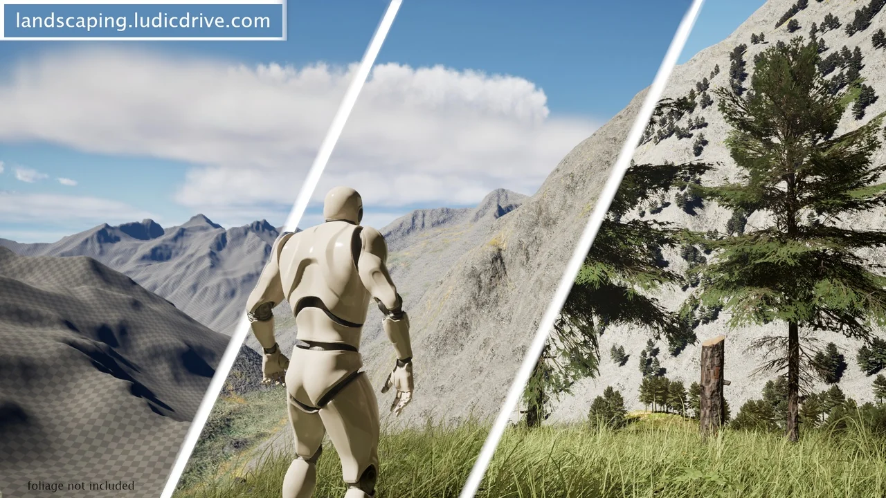
 Procedural Systems
 Procedural Systems
 Engine Tools