"0148f1904a9b0d16"{"id":"1002619","slug":"landscaping-mapbox","title":"Landscaping Mapbox","category":"Engine Tools","engine":"4.25 - 5.8","assetVersion":"Asset Version: 1.0 - 4.0","engineVersion":"Engine Version: 4.25 - 5.8","tag":"Engine Tools","accent":"blue","visual":"mech","summary":"Landscaping Mapbox extends the Landscaping System to download heightmaps, satellite imagery, and vector tiles directly from Mapbox into Unreal Engine.","platform":"Unreal Engine","indexPolicy":"index","publishedAt":"2026-11-14T09:54:00.508Z","updatedAt":"2026-11-14T09:54:00.508Z","sourceNotes":[],"fileContents":[],"compatibility":["Unreal Engine","Asset Version: 1.0 - 4.0","Engine Version: 4.25 - 5.8"],"featuredImage":{"alt":"Landscaping Mapbox","src":"/wp-content/uploads/published/2026/11/06ce7e6834ae-a6fc955e-9af6-4ba0-9561-b27edca36dff-d4b98ec4f2.webp"},"hasDownloadLink":true,"downloads":0,"terms":[{"taxonomy":"category","slug":"engine-tools-tools-and-plugins","name":"Engine Tools"}],"galleryImages":[{"src":"/wp-content/uploads/published/2026/11/924d3487ac09-acc833b7-7336-4912-9230-98c429f091db-acc140e1a1.webp","alt":"Landscaping Mapbox"},{"src":"/wp-content/uploads/published/2026/11/988b02a88e80-64ec097d-dcbb-4992-b330-03d853aa45c1-2a4c85015a.webp","alt":"Landscaping Mapbox"},{"src":"/wp-content/uploads/published/2026/11/605943b3c788-e3b37075-bd17-4e22-b93f-2b61db452aa3-79bf3ae891.webp","alt":"Landscaping Mapbox"}],"accessPanel":{"kind":"resource","title":"Get this resource","eyebrow":"Free resource","message":"Download this resource in your browser.","fileName":"Landscaping Mapbox.7z","safetyNote":"Resources are manually reviewed before listing to improve quality and reduce obvious risks.","actionLabel":"Get this resource","resourceType":"Resource archive","versions":[]},"contentHtml":"\u003ch2\u003eReal-World Geographic Capture with Landscaping Mapbox\u003c/h2\u003e\n\u003cp\u003eGeographic Information Systems (GIS) and real-world simulation environments require authentic surface topologies rather than synthetic procedural hills. Landscaping Mapbox addresses this technical need by functioning as a dedicated extension of the Landscaping System, coupling the engine's landscape generation capabilities with global cartographic and elevation datasets. By channeling measured terrain surfaces directly into the development workspace, the extension eliminates the friction of manual geospatial data conversions, file reformatting, and coordinate alignment.\u003c/p\u003e\n\u003cp\u003eReal-world terrain modeling presents immediate technical demands regarding vertical fidelity, surface coverage, and reference imagery. Landscaping Mapbox bridges this gap by directly interfacing with real-world spatial coordinates to pull three fundamental data formats: raster heightmaps, visual satellite imagery, and structural vector tiles. Whether establishing expansive terrains for defense training, aviation flight paths, or realistic simulation environments, the extension translates raw global metrics into actionable terrain assets ready for immediate scene construction.\u003c/p\u003e \u003ch2\u003eMapbox Tile Allocations and Account Integration\u003c/h2\u003e\n\u003cp\u003eTo establish data synchronization between the external servers and the engine pipeline, Landscaping Mapbox relies on an active Mapbox account. The integration requires users to complete a free registration through Mapbox in order to obtain an API key. Once entered, this API key validates communication with the server infrastructure, granting immediate access to automated downloads of global geographic assets without requiring intermediate third-party conversion software.\u003c/p\u003e\n\u003cp\u003eOperating within the standard free tier of a Mapbox account provides substantial operational capacity for environment building. The free tier includes an allowance of 750,000 raster tiles alongside 200,000 vector tiles. In the context of the plugin's data architecture, the 750,000 raster quota covers both raw elevation heightmaps and visual satellite imagery. Because spatial heightmap downloads are partitioned efficiently across raster grid units, this allocation supplies far more data than developers will typically ever need for standard heightmap extraction. This high baseline allowance ensures that technical artists and world builders can sample, test, and extract comprehensive regional maps without immediately exceeding standard usage limits.\u003c/p\u003e \u003ch2\u003eLandscaping System Integration and Interactive Selection\u003c/h2\u003e\n\u003cp\u003eThe core design of Landscaping Mapbox is conceived specifically as an extension of the Landscaping System. While the extension contains dedicated retrieval modules, the Landscaping System is necessary to harness the full power of fast, real-world heightmap imports directly inside the editor viewport.\u003c/p\u003e\n\u003cp\u003eWhen deployed alongside the full Landscaping System, the import workflow is consolidated into an interactive visual process. Technical creators open the geographic mapping interface, identify the precise target territory, select the bounding area directly on the interactive map, and trigger the import command. From that single action, the system automatically resolves the bounds, downloads the corresponding heightmap files, aligns the underlying coordinates, and constructs the native Unreal Engine Landscape geometry. This integrated methodology provides an exceptionally fast workflow for blocking out authentic real-world geographies, ensuring that elevation profiles accurately match natural terrestrial contours without manual coordinate calculation.\u003c/p\u003e \u003ch2\u003eStandalone Programmatic Heightmap Downloads\u003c/h2\u003e\n\u003cp\u003eWhile the full visual workflow requires the Landscaping System, Landscaping Mapbox also offers a functional pathway when operating without the primary Landscaping plugin installed. In this decoupled state, developers can execute programmatic downloads of heightmaps to fetch raw elevation data directly from external servers.\u003c/p\u003e\n\u003cp\u003eThis programmatic access mode is engineered to retrieve raw heightmap data that is immediately ready for native Unreal Engine Landscape generation. Technical directors and pipeline engineers who maintain proprietary landscape construction scripts, automated command-line builds, or procedural generation toolsets can utilize the extension's download architecture as a headless data acquisition bridge. By allowing programmatic calls to return raw heightmap formats directly, the tool accommodates custom pipeline integrations while preserving the automated retrieval benefits of the Mapbox API integration.\u003c/p\u003e \u003ch2\u003eIntelligent Caching Across Mapbox Data Types\u003c/h2\u003e\n\u003cp\u003eTerrain generation and GIS simulation projects regularly involve repetitive iterations over the same geographic bounding boxes. Modifying terrain materials, re-evaluating component resolutions, or rebuilding landscape sections can result in redundant network requests if every iteration queries external servers anew. To prevent unnecessary bandwidth consumption and preserve API allowances, Landscaping Mapbox implements an intelligent caching architecture.\u003c/p\u003e\n\u003cp\u003eThe internal caching system stores all retrieved heightmaps, satellite imagery, and vector tiles locally upon their initial download. When an artist or simulation engineer reimports an area or recalculates terrain layers within a previously queried territory, Landscaping Mapbox checks the local cache first. By referencing the cached data instead of dispatching new network queries, the plugin saves API calls, insulates users from connection interruptions, and dramatically accelerates turnaround times during iterative landscape rebuilding. This localized data retention ensures that complex projects make conservative use of their 750,000 raster and 200,000 vector tile allocations.\u003c/p\u003e \u003ch2\u003eHandling Expansive Extents Over 200 km²\u003c/h2\u003e\n\u003cp\u003eSimulating authentic terrestrial environments often demands scale that extends far beyond small, enclosed playable zones. Landscaping Mapbox is built to execute fast imports across massive physical scales, with verified support for importing landscapes exceeding 200 square kilometers (200 km²). Handling surface coverage of this magnitude ensures that large geographic features—such as mountain ranges, valleys, and river networks—remain continuous and geologically cohesive.\u003c/p\u003e\n\u003cp\u003eThe ability to import over 200 km² rapidly makes the plugin particularly valuable for large-scale simulation domains, such as flight training simulators, vehicular testing spaces, and broad GIS research visualizations. By coordinating the automated download of heightmaps, satellite imagery for ground truth reference, and vector tiles for geographic layout, Landscaping Mapbox streamlines the pipeline between geographic source data and high-fidelity Unreal Engine landscapes.\u003c/p\u003e\n\n\u003ch2\u003eMore From The Same Workflow\u003c/h2\u003e\n\u003cul\u003e\n\u003cli\u003e\u003ca href=\"https://3dcghub.com/landscaping/\" rel=\"noopener noreferrer\"\u003eLandscaping\u003c/a\u003e\u003c/li\u003e\n\u003cli\u003e\u003ca href=\"https://3dcghub.com/landscaping-garden-1/\" rel=\"noopener noreferrer\"\u003eLandscaping Garden 1\u003c/a\u003e\u003c/li\u003e\n\u003cli\u003e\u003ca href=\"https://3dcghub.com/landscaping-small-trees-1/\" rel=\"noopener noreferrer\"\u003eLandscaping Small Trees 1\u003c/a\u003e\u003c/li\u003e\n\u003cli\u003e\u003ca href=\"https://3dcghub.com/runtime-audio-importer/\" rel=\"noopener noreferrer\"\u003eRuntime Audio Importer\u003c/a\u003e\u003c/li\u003e\n\u003cli\u003e\u003ca href=\"https://3dcghub.com/landscaping-aquatic-plants/\" rel=\"noopener noreferrer\"\u003eLandscaping Aquatic Plants\u003c/a\u003e\u003c/li\u003e\n\u003c/ul\u003e","contentTextLength":6913,"navigation":{"current":22,"total":4543,"previous":{"id":"1002620","slug":"runtime-audio-importer-metasound","title":"Runtime Audio Importer (MetaSound)","category":"Engine Tools","platform":"Unreal Engine","updatedAt":"2026-11-14T09:54:39.019Z"},"next":{"id":"1002618","slug":"ultimate-character","title":"Ultimate Character","category":"Action-Adventure","platform":"Unreal Engine","updatedAt":"2026-11-14T09:13:01.059Z"}},"relatedResources":[{"id":"15285","slug":"landscaping","title":"Landscaping","category":"Procedural Systems","engine":"4.26 - 5.6","assetVersion":"Asset Version: 4.3 - 7.25","engineVersion":"Engine version: 4.26 - 5.6","tag":"Procedural Systems","accent":"blue","visual":"luts","summary":"Streamline your terrain creation process with Landscaping, a tool designed to import GIS data directly into Unreal Engine. Transform DTMs and satellite imagery into high-fidelity landscapes without external preparation.","platform":"Unreal Engine","indexPolicy":"noindex","publishedAt":"2026-03-12T08:29:46.000Z","updatedAt":"2026-09-30T05:04:36.509Z","sourceNotes":[],"fileContents":[],"compatibility":["Unreal Engine","Asset Version: 4.3 - 7.25","Engine version: 4.26 - 5.6"],"featuredImage":{"alt":"Landscaping","src":"https://3dcghub.com/wp-content/uploads/2026/03/9f060901-3780-434e-948f-d12892bf7327.webp"},"hasDownloadLink":true,"downloads":3},{"id":"1001468","slug":"landscaping-garden-1","title":"Landscaping Garden 1","category":"Forest \u0026 Jungle","engine":"5.1+","assetVersion":"","engineVersion":"Engine Version: 5.1+","tag":"Forest \u0026 Jungle","accent":"blue","visual":"mech","summary":"Landscaping Garden 1 provides Nanite and Pivot Painter 2.0 vegetation assets, editable PBR materials, and blueprint setups for Unreal Engine 5.0+.","platform":"Unreal Engine","indexPolicy":"index","publishedAt":"2026-10-08T08:17:47.348Z","updatedAt":"2026-10-08T08:17:47.348Z","sourceNotes":[],"fileContents":[],"compatibility":["Unreal Engine","Engine Version: 5.1+"],"featuredImage":{"alt":"Landscaping Garden 1","src":"/wp-content/uploads/published/2026/10/399d01e121df-86e0c99b-2bdb-4574-a5a0-39dae7f90b24-f2d05fd3a1.webp"},"hasDownloadLink":true,"downloads":0},{"id":"1000999","slug":"landscaping-small-trees-1","title":"Landscaping Small Trees 1","category":"Trees","engine":"5.1+","assetVersion":"","engineVersion":"Engine Version: 5.1+","tag":"Trees","accent":"blue","visual":"mech","summary":"Landscaping Small Trees 1 uses Pivot Painter 2.0 for natural movement and Nanite for detailed geometry, with editable PBR materials and Unreal Engine 5.0+ suppo","platform":"Unreal Engine","indexPolicy":"index","publishedAt":"2026-08-19T16:12:52.291Z","updatedAt":"2026-08-19T16:12:52.291Z","sourceNotes":[],"fileContents":[],"compatibility":["Unreal Engine","Engine Version: 5.1+"],"featuredImage":{"alt":"Landscaping Small Trees 1","src":"/wp-content/uploads/published/2026/08/0fe73543c779-ec1d14ee-4e9f-40fa-81ed-9e692d0837c9-a4cd999d22.webp"},"hasDownloadLink":true,"downloads":1}]}
Engine Tools
Landscaping Mapbox
Landscaping Mapbox extends the Landscaping System to download heightmaps, satellite imagery, and vector tiles directly from Mapbox into Unreal Engine.
Real-World Geographic Capture with Landscaping Mapbox
Geographic Information Systems (GIS) and real-world simulation environments require authentic surface topologies rather than synthetic procedural hills. Landscaping Mapbox addresses this technical need by functioning as a dedicated extension of the Landscaping System, coupling the engine's landscape generation capabilities with global cartographic and elevation datasets. By channeling measured terrain surfaces directly into the development workspace, the extension eliminates the friction of manual geospatial data conversions, file reformatting, and coordinate alignment.
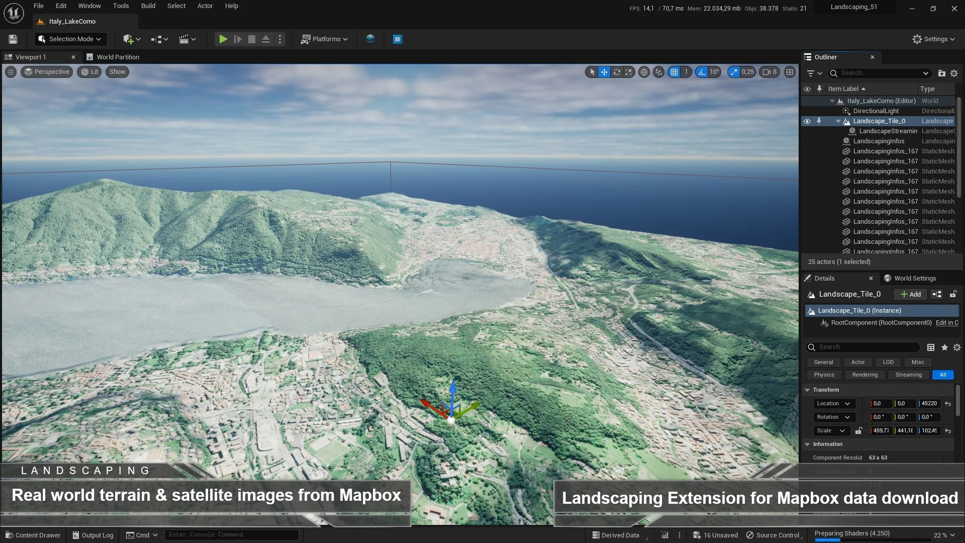
Real-world terrain modeling presents immediate technical demands regarding vertical fidelity, surface coverage, and reference imagery. Landscaping Mapbox bridges this gap by directly interfacing with real-world spatial coordinates to pull three fundamental data formats: raster heightmaps, visual satellite imagery, and structural vector tiles. Whether establishing expansive terrains for defense training, aviation flight paths, or realistic simulation environments, the extension translates raw global metrics into actionable terrain assets ready for immediate scene construction.
Mapbox Tile Allocations and Account Integration
To establish data synchronization between the external servers and the engine pipeline, Landscaping Mapbox relies on an active Mapbox account. The integration requires users to complete a free registration through Mapbox in order to obtain an API key. Once entered, this API key validates communication with the server infrastructure, granting immediate access to automated downloads of global geographic assets without requiring intermediate third-party conversion software.
Operating within the standard free tier of a Mapbox account provides substantial operational capacity for environment building. The free tier includes an allowance of 750,000 raster tiles alongside 200,000 vector tiles. In the context of the plugin's data architecture, the 750,000 raster quota covers both raw elevation heightmaps and visual satellite imagery. Because spatial heightmap downloads are partitioned efficiently across raster grid units, this allocation supplies far more data than developers will typically ever need for standard heightmap extraction. This high baseline allowance ensures that technical artists and world builders can sample, test, and extract comprehensive regional maps without immediately exceeding standard usage limits.
Landscaping System Integration and Interactive Selection
The core design of Landscaping Mapbox is conceived specifically as an extension of the Landscaping System. While the extension contains dedicated retrieval modules, the Landscaping System is necessary to harness the full power of fast, real-world heightmap imports directly inside the editor viewport.
When deployed alongside the full Landscaping System, the import workflow is consolidated into an interactive visual process. Technical creators open the geographic mapping interface, identify the precise target territory, select the bounding area directly on the interactive map, and trigger the import command. From that single action, the system automatically resolves the bounds, downloads the corresponding heightmap files, aligns the underlying coordinates, and constructs the native Unreal Engine Landscape geometry. This integrated methodology provides an exceptionally fast workflow for blocking out authentic real-world geographies, ensuring that elevation profiles accurately match natural terrestrial contours without manual coordinate calculation.
Standalone Programmatic Heightmap Downloads
While the full visual workflow requires the Landscaping System, Landscaping Mapbox also offers a functional pathway when operating without the primary Landscaping plugin installed. In this decoupled state, developers can execute programmatic downloads of heightmaps to fetch raw elevation data directly from external servers.
This programmatic access mode is engineered to retrieve raw heightmap data that is immediately ready for native Unreal Engine Landscape generation. Technical directors and pipeline engineers who maintain proprietary landscape construction scripts, automated command-line builds, or procedural generation toolsets can utilize the extension's download architecture as a headless data acquisition bridge. By allowing programmatic calls to return raw heightmap formats directly, the tool accommodates custom pipeline integrations while preserving the automated retrieval benefits of the Mapbox API integration.
Intelligent Caching Across Mapbox Data Types
Terrain generation and GIS simulation projects regularly involve repetitive iterations over the same geographic bounding boxes. Modifying terrain materials, re-evaluating component resolutions, or rebuilding landscape sections can result in redundant network requests if every iteration queries external servers anew. To prevent unnecessary bandwidth consumption and preserve API allowances, Landscaping Mapbox implements an intelligent caching architecture.
The internal caching system stores all retrieved heightmaps, satellite imagery, and vector tiles locally upon their initial download. When an artist or simulation engineer reimports an area or recalculates terrain layers within a previously queried territory, Landscaping Mapbox checks the local cache first. By referencing the cached data instead of dispatching new network queries, the plugin saves API calls, insulates users from connection interruptions, and dramatically accelerates turnaround times during iterative landscape rebuilding. This localized data retention ensures that complex projects make conservative use of their 750,000 raster and 200,000 vector tile allocations.
Handling Expansive Extents Over 200 km²
Simulating authentic terrestrial environments often demands scale that extends far beyond small, enclosed playable zones. Landscaping Mapbox is built to execute fast imports across massive physical scales, with verified support for importing landscapes exceeding 200 square kilometers (200 km²). Handling surface coverage of this magnitude ensures that large geographic features—such as mountain ranges, valleys, and river networks—remain continuous and geologically cohesive.
The ability to import over 200 km² rapidly makes the plugin particularly valuable for large-scale simulation domains, such as flight training simulators, vehicular testing spaces, and broad GIS research visualizations. By coordinating the automated download of heightmaps, satellite imagery for ground truth reference, and vector tiles for geographic layout, Landscaping Mapbox streamlines the pipeline between geographic source data and high-fidelity Unreal Engine landscapes.
 Engine Tools
 Procedural Systems
 Forest & Jungle
 Trees