"a338a1d501976271"{"id":"1000308","slug":"landscape-combinator","title":"Landscape Combinator","category":"Procedural Systems","engine":"5.6 - 5.7","assetVersion":"Asset Version: 0.7.3 - 0.8.0","engineVersion":"Engine Version: 5.6 - 5.7","tag":"Procedural Systems","accent":"blue","visual":"city","summary":"Generate real-world environments in Unreal Engine 5.7 using heightmaps, OSM data, and GDAL vectors with Landscape Combinator's procedural generation tools.","platform":"Unreal Engine","publishedAt":"2026-07-04T09:38:35.413Z","updatedAt":"2026-07-04T09:38:35.413Z","sourceNotes":[],"fileContents":[],"compatibility":["Unreal Engine","Asset Version: 0.7.3 - 0.8.0","Engine Version: 5.6 - 5.7"],"featuredImage":{"alt":"Landscape Combinator","src":"/wp-content/uploads/published/2026/07/624779d18abb-9249171c-8831-4064-8144-29a8d8128f4d-8e5f25fd31.webp"},"hasDownloadLink":true,"downloads":1,"terms":[{"taxonomy":"category","slug":"procedural-systems-tools-and-plugins","name":"Procedural Systems"}],"galleryImages":[{"src":"/wp-content/uploads/published/2026/07/4dcf2e4e8fe9-66b84145-d807-4037-8f31-dd2baf5804ec-50300a0d54.webp","alt":"Landscape Combinator"},{"src":"/wp-content/uploads/published/2026/07/fb9c2a215d2e-846f4d0d-22bf-47b5-996d-1cbcfafa5d2e-a3e7fae224.webp","alt":"Landscape Combinator"},{"src":"/wp-content/uploads/published/2026/07/3a1922d2de56-d5809335-b6f8-4991-a6f2-2149e05ddc44-f4d7c7ecc6.webp","alt":"Landscape Combinator"},{"src":"/wp-content/uploads/published/2026/07/37a019dc2215-42a7c13b-be7f-4981-8318-7d8740139616-331e987987.webp","alt":"Landscape Combinator"}],"accessPanel":{"kind":"resource","title":"Download this resource","eyebrow":"Free Download","message":"Log in or create a free account to start your download.","fileName":"Landscape Combinator.7z","safetyNote":"Resources are manually reviewed before listing to improve quality and reduce obvious risks.","actionLabel":"Download Free","resourceType":"Resource archive"},"contentHtml":"\u003ch2\u003eTranslating Real-World Heightmaps into Playable Topography\u003c/h2\u003e\n\u003cp\u003eBuilding expansive environments often begins with raw elevation data, and transforming that data into a functional game environment requires dedicated translation tools. Landscape Combinator operates strictly within Unreal Engine 5.7 to handle this exact pipeline, allowing developers to generate native landscapes directly from real-world heightmaps. Instead of manually sculpting mountain ranges, valleys, or coastal cliffs, environment artists can rely on geographic data to form the foundation of their scenes.\u003c/p\u003e\n\u003cp\u003eTo help developers immediately visualize the imported topography, the system includes a basic landscape material. This temporary surfacing ensures that the raw heightmap data is readable the moment it generates in the engine, providing a clear view of the terrain’s slopes, peaks, and flatlands before custom, high-fidelity materials are applied. This accelerates the initial block-out phase, allowing teams to confirm the accuracy of their geographic data without needing to build complex auto-materials beforehand.\u003c/p\u003e\n\u003ch2\u003eAutomating Infrastructure with OpenStreetMap Data\u003c/h2\u003e\n\u003cp\u003eOnce the raw terrain is established, populating it with roads and urban infrastructure typically demands extensive manual labor. This plugin accelerates that phase by reading OpenStreetMap (OSM) data and converting it directly into landscape splines. Because OSM data contains highly accurate vector lines mapping out real-world streets, paths, and boundaries, the generation process accurately reflects actual geographic layouts.\u003c/p\u003e\n\u003cp\u003eBeyond plotting road networks, the system utilizes this same OSM integration to construct urban environments. The tool reads the specific splines that represent building outlines within the OSM dataset. Using these exact footprints, it automatically generates buildings across the landscape. This capability allows developers to populate vast city grids, rural towns, or isolated industrial zones without having to manually place individual structures. The resulting architecture mirrors the real-world scale and positioning dictated by the original map data, providing a rapid structural foundation for any location on earth.\u003c/p\u003e\n\u003ch2\u003eDriving Procedural Forests via GDAL Vector Files\u003c/h2\u003e\n\u003cp\u003eNatural environments require just as much spatial accuracy as urban centers. To handle the distribution of natural biomes, Landscape Combinator utilizes procedural generation driven by vector files. Developers can feed OSM data or any other vector formats supported by GDAL into the system to define exactly where specific vegetation should grow.\u003c/p\u003e\n\u003cp\u003eBy mapping out these vector boundaries, the plugin automatically adds procedural foliage across the generated terrain. If a real-world location features a dense pine forest or a sparse woodland, the vector data outlines those exact perimeters. The system then populates those designated zones with foliage, ensuring that the tree lines match the authentic geographic distribution. This removes the need to manually paint foliage volumes over massive open worlds, as the vector files dictate the exact spread and density boundaries of the procedural systems.\u003c/p\u003e\n\u003ch2\u003eSpatial Alignment Across Multiple Landscape Resolutions\u003c/h2\u003e\n\u003cp\u003eOne of the most complex challenges in handling GIS data and heightmaps is ensuring that separate pieces of terrain align seamlessly, especially when dealing with massive spatial scales. When generating a landscape for a real-world location, the plugin automatically calculates and adjusts its position and scale correctly within a planar world.\u003c/p\u003e\n\u003cp\u003eThis automated alignment opens up highly flexible workflows for environment optimization. Developers are not restricted to using a single, uniformly dense heightmap for an entire game world. Instead, they can create several real-world landscapes of varying quality and resolution. A localized, highly detailed heightmap can be generated for the primary playable area, while lower-quality heightmaps can be utilized for distant mountains or unreachable background vistas. Because the plugin understands the geographic coordinates and scale of each piece, it places and scales them correctly with respect to one another. The different terrain pieces lock into their proper planar positions automatically, forming a cohesive world without requiring environment artists to manually shift, scale, or stitch the edges of mismatched topographies.\u003c/p\u003e\n\u003ch2\u003eEngine Compatibility and Asset Dependencies\u003c/h2\u003e\n\u003cp\u003eOperating as a dedicated Unreal Engine 5.7 plugin, the toolset is suited to deployment on both Windows and Linux platforms. The system functions strictly as a data-translation and generation framework, meaning it dictates the layout, scale, and placement of the world without forcing a specific visual style upon the project.\u003c/p\u003e\n\u003cp\u003eWhile promotional captures of the plugin demonstrate dense, photorealistic environments, the high-quality assets used in those demonstrations are not included in the package. Specific elements like the Temperate Vegetation: Spruce Forest pack, Megascans foliage, and high-quality textures must be sourced separately. These assets remain freely available on the Unreal Engine Marketplace, allowing developers to plug high-end visuals into the framework once the OSM and heightmap data have established the foundational world. The plugin itself focuses entirely on the structural generation, leaving the final art direction and asset selection completely in the hands of the environment team.\u003c/p\u003e\n\u003cp\u003eFor development teams evaluating the toolset or working outside of commercial constraints, the plugin and its complete source code are available for free on GitHub for non-commercial projects. This allows artists and programmers to test the data importation pipelines, experiment with OSM building generation, or review the planar world scaling features before fully integrating the system into a commercial production environment.\u003c/p\u003e\n\n\u003ch2\u003eMore From The Same Workflow\u003c/h2\u003e\n\u003cul\u003e\n\u003cli\u003e\u003ca href=\"https://3dcghub.com/terracrust-procedural-landscape/\" title=\"Terracrust: Procedural Landscape\"\u003eTerracrust: Procedural Landscape\u003c/a\u003e\u003c/li\u003e\n\u003cli\u003e\u003ca href=\"https://3dcghub.com/procedural-nature-generator/\" title=\"Procedural Nature Generator\"\u003eProcedural Nature Generator\u003c/a\u003e\u003c/li\u003e\n\u003cli\u003e\u003ca href=\"https://3dcghub.com/landscaping/\" title=\"Landscaping\"\u003eLandscaping\u003c/a\u003e\u003c/li\u003e\n\u003cli\u003e\u003ca href=\"https://3dcghub.com/easy-flight-model/\" title=\"Easy Flight Model\"\u003eEasy Flight Model\u003c/a\u003e\u003c/li\u003e\n\u003cli\u003e\u003ca href=\"https://3dcghub.com/crazy-ivy-realistic-ivy-generator-vine-plugin-grow-procedural-plants-in-editor/\" title=\"Crazy Ivy Realistic Ivy Generator Vine Plugin - Grow Procedural Plants in Editor\"\u003eCrazy Ivy Realistic Ivy Generator Vine Plugin - Grow Procedural Plants in Editor\u003c/a\u003e\u003c/li\u003e\n\u003c/ul\u003e","contentTextLength":6086,"navigation":{"current":1168,"total":3338,"previous":{"id":"1000310","slug":"magic-rune-vfx","title":"Magic Rune VFX","category":"Spells \u0026 Combat","platform":"Unreal Engine","updatedAt":"2026-07-04T10:19:46.112Z"},"next":{"id":"1000307","slug":"knights-pack","title":"Knights (Pack)","category":"Characters \u0026 Creatures","platform":"Unreal Engine","updatedAt":"2026-07-04T09:34:36.390Z"}},"relatedResources":[{"id":"15315","slug":"procedural-nature-generator","title":"Procedural Nature Generator","category":"Procedural Systems","engine":"5.3","assetVersion":"Engine version: 5.3","engineVersion":"4.26","tag":"Procedural Systems","accent":"blue","visual":"character","summary":"The Procedural Nature Generator is a powerful editor plugin for creating dense natural environments. It allows developers to populate landscapes with thousands of actors in seconds using custom assets.","platform":"Unreal Engine","publishedAt":"2026-03-12T08:35:35.000Z","updatedAt":"2026-04-19T15:44:50.000Z","sourceNotes":[],"fileContents":[],"compatibility":["Unreal Engine","Engine version: 5.3"],"featuredImage":{"alt":"Procedural Nature Generator","src":"https://3dcghub.com/wp-content/uploads/2026/03/9983a12a-a0ea-4b90-aef5-8d43cf058002.webp"},"hasDownloadLink":true,"downloads":1},{"id":"15372","slug":"terracrust-procedural-landscape","title":"Terracrust: Procedural Landscape","category":"Procedural Systems","engine":"5.4","assetVersion":"Engine version: 5.4","engineVersion":"Asset Version:1.0","tag":"Procedural Systems","accent":"blue","visual":"city","summary":"Terracrust is a powerful toolset for procedurally generating landscape brushes. It features a custom graph editor and GPU-based processing to streamline environment creation.","platform":"Unreal Engine","publishedAt":"2026-03-12T08:48:44.000Z","updatedAt":"2026-04-19T15:44:48.000Z","sourceNotes":[],"fileContents":[],"compatibility":["Unreal Engine","Engine version: 5.4","Asset Version: 1.0"],"featuredImage":{"alt":"Terracrust: Procedural Landscape","src":"https://3dcghub.com/wp-content/uploads/2026/03/80ced2da-cb2e-4a59-8b31-10de011ac15d.webp"},"hasDownloadLink":true,"downloads":0},{"id":"15285","slug":"landscaping","title":"Landscaping","category":"Procedural Systems","engine":"4.26 - 5.6","assetVersion":"Asset Version: 4.3 - 7.25","engineVersion":"Engine version: 4.26 - 5.6","tag":"Procedural Systems","accent":"blue","visual":"luts","summary":"Streamline your terrain creation process with Landscaping, a tool designed to import GIS data directly into Unreal Engine. Transform DTMs and satellite imagery into high-fidelity landscapes without external preparation.","platform":"Unreal Engine","publishedAt":"2026-03-12T08:29:46.000Z","updatedAt":"2026-09-30T05:04:36.509Z","sourceNotes":[],"fileContents":[],"compatibility":["Unreal Engine","Asset Version: 4.3 - 7.25","Engine version: 4.26 - 5.6"],"featuredImage":{"alt":"Landscaping","src":"https://3dcghub.com/wp-content/uploads/2026/03/9f060901-3780-434e-948f-d12892bf7327.webp"},"hasDownloadLink":true,"downloads":2}]}
Procedural Systems
Landscape Combinator
Generate real-world environments in Unreal Engine 5.7 using heightmaps, OSM data, and GDAL vectors with Landscape Combinator's procedural generation tools.
Translating Real-World Heightmaps into Playable Topography
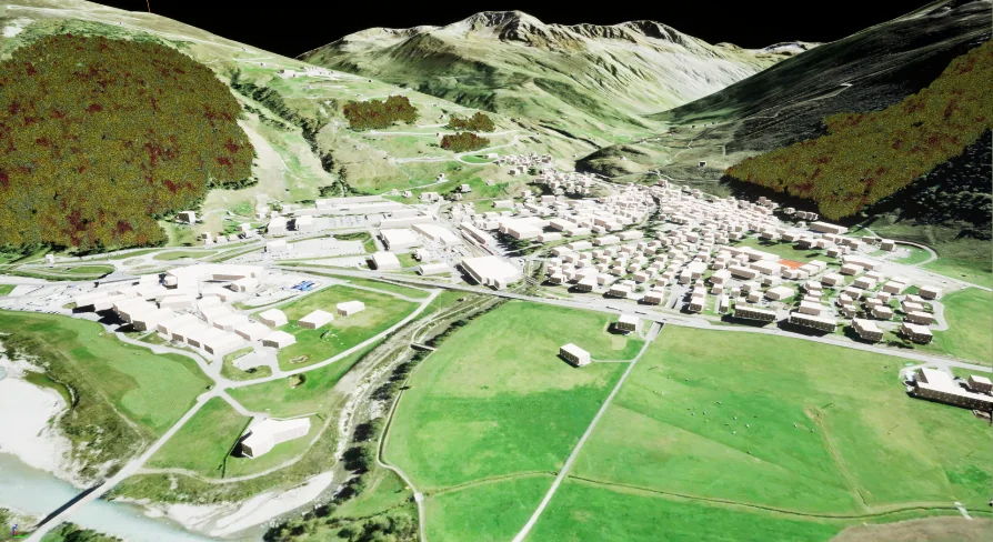
Building expansive environments often begins with raw elevation data, and transforming that data into a functional game environment requires dedicated translation tools. Landscape Combinator operates strictly within Unreal Engine 5.7 to handle this exact pipeline, allowing developers to generate native landscapes directly from real-world heightmaps. Instead of manually sculpting mountain ranges, valleys, or coastal cliffs, environment artists can rely on geographic data to form the foundation of their scenes.
To help developers immediately visualize the imported topography, the system includes a basic landscape material. This temporary surfacing ensures that the raw heightmap data is readable the moment it generates in the engine, providing a clear view of the terrain’s slopes, peaks, and flatlands before custom, high-fidelity materials are applied. This accelerates the initial block-out phase, allowing teams to confirm the accuracy of their geographic data without needing to build complex auto-materials beforehand.
Automating Infrastructure with OpenStreetMap Data
Once the raw terrain is established, populating it with roads and urban infrastructure typically demands extensive manual labor. This plugin accelerates that phase by reading OpenStreetMap (OSM) data and converting it directly into landscape splines. Because OSM data contains highly accurate vector lines mapping out real-world streets, paths, and boundaries, the generation process accurately reflects actual geographic layouts.
Beyond plotting road networks, the system utilizes this same OSM integration to construct urban environments. The tool reads the specific splines that represent building outlines within the OSM dataset. Using these exact footprints, it automatically generates buildings across the landscape. This capability allows developers to populate vast city grids, rural towns, or isolated industrial zones without having to manually place individual structures. The resulting architecture mirrors the real-world scale and positioning dictated by the original map data, providing a rapid structural foundation for any location on earth.
Driving Procedural Forests via GDAL Vector Files
Natural environments require just as much spatial accuracy as urban centers. To handle the distribution of natural biomes, Landscape Combinator utilizes procedural generation driven by vector files. Developers can feed OSM data or any other vector formats supported by GDAL into the system to define exactly where specific vegetation should grow.
By mapping out these vector boundaries, the plugin automatically adds procedural foliage across the generated terrain. If a real-world location features a dense pine forest or a sparse woodland, the vector data outlines those exact perimeters. The system then populates those designated zones with foliage, ensuring that the tree lines match the authentic geographic distribution. This removes the need to manually paint foliage volumes over massive open worlds, as the vector files dictate the exact spread and density boundaries of the procedural systems.
Spatial Alignment Across Multiple Landscape Resolutions
One of the most complex challenges in handling GIS data and heightmaps is ensuring that separate pieces of terrain align seamlessly, especially when dealing with massive spatial scales. When generating a landscape for a real-world location, the plugin automatically calculates and adjusts its position and scale correctly within a planar world.
This automated alignment opens up highly flexible workflows for environment optimization. Developers are not restricted to using a single, uniformly dense heightmap for an entire game world. Instead, they can create several real-world landscapes of varying quality and resolution. A localized, highly detailed heightmap can be generated for the primary playable area, while lower-quality heightmaps can be utilized for distant mountains or unreachable background vistas. Because the plugin understands the geographic coordinates and scale of each piece, it places and scales them correctly with respect to one another. The different terrain pieces lock into their proper planar positions automatically, forming a cohesive world without requiring environment artists to manually shift, scale, or stitch the edges of mismatched topographies.
Engine Compatibility and Asset Dependencies
Operating as a dedicated Unreal Engine 5.7 plugin, the toolset is suited to deployment on both Windows and Linux platforms. The system functions strictly as a data-translation and generation framework, meaning it dictates the layout, scale, and placement of the world without forcing a specific visual style upon the project.
While promotional captures of the plugin demonstrate dense, photorealistic environments, the high-quality assets used in those demonstrations are not included in the package. Specific elements like the Temperate Vegetation: Spruce Forest pack, Megascans foliage, and high-quality textures must be sourced separately. These assets remain freely available on the Unreal Engine Marketplace, allowing developers to plug high-end visuals into the framework once the OSM and heightmap data have established the foundational world. The plugin itself focuses entirely on the structural generation, leaving the final art direction and asset selection completely in the hands of the environment team.
For development teams evaluating the toolset or working outside of commercial constraints, the plugin and its complete source code are available for free on GitHub for non-commercial projects. This allows artists and programmers to test the data importation pipelines, experiment with OSM building generation, or review the planar world scaling features before fully integrating the system into a commercial production environment.
 Procedural Systems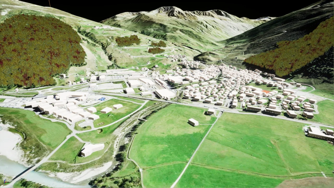
 Procedural Systems
 Procedural Systems
 Procedural Systems