"95fdaf16012263fa"{"id":"1002320","slug":"height-maps-pack","title":"Height Maps Pack","category":"Desert","engine":"4.26+,5.0+","assetVersion":"","engineVersion":"Engine Version: 4.26+,5.0+","tag":"Desert","accent":"blue","visual":"mech","summary":"Twenty-one 4096x4096 height maps for landscape terrain: canyon, desert, volcano, mountain, erosion and craters, plus OBJ files and Marble Materials compatibilit","platform":"Unreal Engine","indexPolicy":"index","publishedAt":"2026-11-06T06:21:42.641Z","updatedAt":"2026-11-06T06:21:42.641Z","sourceNotes":[],"fileContents":[],"compatibility":["Unreal Engine","Engine Version: 4.26+,5.0+"],"featuredImage":{"alt":"Height Maps Pack","src":"/wp-content/uploads/published/2026/11/4f234fbb384b-693ee1aa-51f0-448c-af54-d3e8df7aeb35-a2dfe201e8.webp"},"hasDownloadLink":true,"downloads":0,"terms":[{"taxonomy":"category","slug":"desert","name":"Desert"}],"galleryImages":[{"src":"/wp-content/uploads/published/2026/11/b22ced0f6333-3b997ae0-3065-4ebd-bbc8-b73eab918865-45436785c4.webp","alt":"Height Maps Pack"},{"src":"/wp-content/uploads/published/2026/11/f7817f180cfb-80e34869-bc68-4933-94d5-056974f3a55e-1ba4a89dfd.webp","alt":"Height Maps Pack"},{"src":"/wp-content/uploads/published/2026/11/78bbda1d0117-9cb051a6-a5f9-4df1-b14a-cac0c0a09da0-f6e7aa8851.webp","alt":"Height Maps Pack"},{"src":"/wp-content/uploads/published/2026/11/0f19a7d1cf3c-f6372195-e4ed-4ef2-81e5-c35e8ac373d3-418dc1c18f.webp","alt":"Height Maps Pack"},{"src":"/wp-content/uploads/published/2026/11/7d4ad7fe1933-bc724e18-e5f2-4ef0-b419-8197a79fa780-a51be64a56.webp","alt":"Height Maps Pack"},{"src":"/wp-content/uploads/published/2026/11/fc09dc90ba3e-0bbc55ab-8e53-4eec-86be-d04c22d72e1e-1b1094db37.webp","alt":"Height Maps Pack"},{"src":"/wp-content/uploads/published/2026/11/00c45191d06b-87d220c0-b837-48c6-bc99-03189c688c24-ea9846a17b.webp","alt":"Height Maps Pack"},{"src":"/wp-content/uploads/published/2026/11/865aec435975-7fc8ca71-4ef1-4a39-bcd5-fdf818dee605-0b23279ff8.webp","alt":"Height Maps Pack"},{"src":"/wp-content/uploads/published/2026/11/79390fc1315a-d9d11078-9d62-4a71-a829-dc7de337930b-efecb8b912.webp","alt":"Height Maps Pack"},{"src":"/wp-content/uploads/published/2026/11/cfe951531471-8939edf4-6e58-4afa-80a0-197eead6a5fd-84fd741ed0.webp","alt":"Height Maps Pack"}],"accessPanel":{"kind":"resource","title":"Get this resource","eyebrow":"Free resource","message":"3DCGHUB is the service provider for this listing. Access is fulfilled through the official publisher channel.","fileName":"Content.7z","safetyNote":"Resources are manually reviewed before listing to improve quality and reduce obvious risks.","actionLabel":"Get this resource","resourceType":"Resource archive","versions":[]},"contentHtml":"\u003cp\u003eA height map is a grid of numbers, and the first thing it decides in a scene is how far the ground can be pushed before it stops convincing. At 4096 by 4096, the maps in this pack carry ridge lines, slope breaks and small surface unevenness that survive when the camera moves in close. Drop the same terrain into a lower-resolution field and those shapes collapse into visible steps. That resolution holds steady across all twenty-one maps.\u003c/p\u003e \u003ch2\u003eTwenty-one maps, and how the landform types split\u003c/h2\u003e \u003cp\u003eThe count is worth spelling out because it tells you what kind of terrain library this actually is. Two canyon maps, six desert, one volcano, five mountains, one erosion, one craters — and further maps beyond those named categories. The total lands at twenty-one.\u003c/p\u003e \u003cp\u003eSix desert maps against five mountain maps is a noticeably dry weighting. Arid ground gets nearly a third of the set, which suits projects where open, sun-lit terrain appears repeatedly and needs variation rather than one hero vista. A single volcano map and a single craters map sit at the opposite end: one distinctive landform each, useful as a set piece rather than a repeatable background.\u003c/p\u003e \u003cp\u003eThe canyon pair and the erosion map overlap in intent without duplicating each other. Canyons read as carved channels with defined walls; erosion reads as surface wear, the kind of detail that sits on top of a larger form. Used together, an erosion map can break up a canyon floor that would otherwise look too clean.\u003c/p\u003e \u003ch2\u003eDesert, canyon, mountain — the tags behind the terrain types\u003c/h2\u003e \u003cp\u003eThe vocabulary attached to the pack is short: canyon, desert, mountain, level, hill, erosion. Two of those are workflow words rather than geology. \"Level\" and \"hill\" point at how the terrain is meant to be spent — as a base for a playable or explorable space, not as a distant painted backdrop. A hill, in that reading, is a gentler proposition than a mountain: elevation you can walk over rather than elevation that blocks the route.\u003c/p\u003e \u003cp\u003eThat framing changes how the set is best approached. Twenty-one maps is more terrain than most single scenes will ever show at once, so the natural pattern is to pick a terrain family per area — a desert stretch, a mountain approach, a canyon crossing — and let the maps within that family do the variation work.\u003c/p\u003e \u003cp\u003eNone of this terrain corresponds to real places. The maps are invented, built from imagination rather than surveyed from actual elevation data. There is no real-world location to match them against, and no expectation that a satellite or aerial reference will line up with the shapes. For production, that removes the constraint of geographic accuracy entirely: the terrain serves the scene rather than the other way around. It also means surface texturing, vegetation and rock materials are authored decisions, since nothing in the height data is tied to a specific real biome.\u003c/p\u003e \u003ch2\u003eOBJ files that hold the same terrain as geometry\u003c/h2\u003e \u003cp\u003eEvery height map comes with an OBJ counterpart. The difference is practical rather than cosmetic. A height map is a field of values that a landscape system interprets — it needs a terrain tool to become something you can see. An OBJ is already a mesh.\u003c/p\u003e \u003cp\u003eThat gives two entry points into the same terrain. In a modelling application, the OBJ can be rotated, lit and inspected as geometry before any landscape import happens, which makes it useful for judging whether a canyon's proportions suit a shot or whether a mountain's profile reads from a particular angle. In a scene that doesn't run a height-field landscape system at all, the OBJ is the version that works.\u003c/p\u003e \u003ch2\u003eMarble Materials compatibility and where the set fits\u003c/h2\u003e \u003cp\u003eThe pack is compatible with Marble Materials, so terrain built from these maps can be paired with that material set rather than requiring a shader built from scratch. For a team already working in that material pipeline, the terrain and the surfacing side line up without extra bridging work.\u003c/p\u003e \u003cp\u003eIn a production flow, height maps at this resolution usually land early — during layout, when the shape of the ground has to be settled before anything is placed on it. A canyon map establishes where a route pinches. A mountain map sets a horizon. A craters map introduces a landmark. Because all twenty-one maps share the same 4096 resolution, swapping one for another during layout doesn't change the technical footing of the scene, only the terrain.\u003c/p\u003e \u003cp\u003eThe single erosion map deserves separate mention here. Surface wear is often the last thing added and the first thing that looks wrong when skipped. Having it as a dedicated map means weathered ground can be introduced as its own pass instead of being approximated with noise.\u003c/p\u003e \u003ch2\u003eWhat to settle before committing to the set\u003c/h2\u003e \u003cp\u003eThe concrete value sits in the pairing: a 4096 grid for terrain shape, an OBJ for the same shape as mesh, and a named material compatibility that removes an unknown from the surfacing stage. Teams weighing the pack should look at the desert-heavy split first — six of twenty-one — and confirm that arid terrain is genuinely what their scenes need, then check which maps fall outside the listed canyon, desert, volcano, mountain, erosion and crater categories. The twenty-one total leaves room there, and knowing what fills it is more useful than the headline count.\u003c/p\u003e\n\n\u003ch2\u003eExplore Similar Assets\u003c/h2\u003e\n\u003cul\u003e\n\u003cli\u003e\u003ca href=\"https://3dcghub.com/brushify-canyons-pack/\" rel=\"noopener noreferrer\"\u003eBrushify - Canyons Pack\u003c/a\u003e\u003c/li\u003e\n\u003cli\u003e\u003ca href=\"https://3dcghub.com/rocky-desert/\" rel=\"noopener noreferrer\"\u003eRocky Desert\u003c/a\u003e\u003c/li\u003e\n\u003cli\u003e\u003ca href=\"https://3dcghub.com/crimson-desert-landscape/\" rel=\"noopener noreferrer\"\u003eCrimson Desert Landscape\u003c/a\u003e\u003c/li\u003e\n\u003cli\u003e\u003ca href=\"https://3dcghub.com/brushify-dunes-pack/\" rel=\"noopener noreferrer\"\u003eBrushify - Dunes Pack\u003c/a\u003e\u003c/li\u003e\n\u003cli\u003e\u003ca href=\"https://3dcghub.com/red-desert-pack/\" rel=\"noopener noreferrer\"\u003eRed Desert Pack\u003c/a\u003e\u003c/li\u003e\n\u003c/ul\u003e","contentTextLength":5379,"navigation":{"current":48,"total":4291,"previous":{"id":"1002321","slug":"idle-animset-pack","title":"Idle Animset Pack","category":"Variety","platform":"Unreal Engine","updatedAt":"2026-11-06T06:22:51.144Z"},"next":{"id":"1002319","slug":"graffiti-maker-in-game","title":"Graffiti Maker (In-Game)","category":"Gameplay Features","platform":"Unreal Engine","updatedAt":"2026-11-06T06:20:42.223Z"}},"relatedResources":[{"id":"1000934","slug":"brushify-canyons-pack","title":"Brushify - Canyons Pack","category":"Desert","engine":"4.26+,5.0+","assetVersion":"","engineVersion":"Engine Version: 4.26+,5.0+","tag":"Desert","accent":"blue","visual":"mech","summary":"Canyon environment toolkit for Unreal Engine 5 with a playable level, alpha brushes, distance meshes, procedural spawners, and a biome-based landscape material.","platform":"Unreal Engine","indexPolicy":"index","publishedAt":"2026-08-10T02:36:50.580Z","updatedAt":"2026-08-10T02:36:50.580Z","sourceNotes":[],"fileContents":[],"compatibility":["Unreal Engine","Engine Version: 4.26+,5.0+"],"featuredImage":{"alt":"Brushify - Canyons Pack","src":"/wp-content/uploads/published/2026/08/b5fc4aed03c2-4a924bfd-4d43-473d-8806-44ebc7da6204-f15c281bbf.webp"},"hasDownloadLink":true,"downloads":4},{"id":"1001122","slug":"rocky-desert","title":"Rocky Desert","category":"Desert","engine":"4.26+,5.0+","assetVersion":"","engineVersion":"Engine Version: 4.26+,5.0+","tag":"Desert","accent":"blue","visual":"mech","summary":"Desert environment with 15 rock and foliage meshes, 765x765m terrain, terrain tessellation, dynamic atmosphere, LODs, and 2048 textures for next-gen game levels","platform":"Unreal Engine","indexPolicy":"index","publishedAt":"2026-09-07T13:05:56.081Z","updatedAt":"2026-09-07T13:05:56.081Z","sourceNotes":[],"fileContents":[],"compatibility":["Unreal Engine","Engine Version: 4.26+,5.0+"],"featuredImage":{"alt":"Rocky Desert","src":"/wp-content/uploads/published/2026/09/21e8b63ad822-3c8cde2a-ddfe-446b-8cce-a1281d031970-76856ea1ed.webp"},"hasDownloadLink":true,"downloads":1},{"id":"1000362","slug":"crimson-desert-landscape","title":"Crimson Desert Landscape","category":"Desert","engine":"4.26+,5.0+","assetVersion":"","engineVersion":"Engine Version: 4.26+,5.0+","tag":"Desert","accent":"blue","visual":"city","summary":"A fully stylized PBR environment package for Unreal Engine 4, featuring modular desert meshes, layered landscape materials, and high-resolution textures.","platform":"Unreal Engine","indexPolicy":"index","publishedAt":"2026-07-06T07:40:13.165Z","updatedAt":"2026-07-06T07:40:13.165Z","sourceNotes":[],"fileContents":[],"compatibility":["Unreal Engine","Engine Version: 4.26+,5.0+"],"featuredImage":{"alt":"Crimson Desert Landscape","src":"/wp-content/uploads/published/2026/07/beb10262ebcb-af97d694-2740-402a-8b01-55e38009ab79-a5923630c9.webp"},"hasDownloadLink":true,"downloads":0}]}
Desert
Height Maps Pack
Twenty-one 4096x4096 height maps for landscape terrain: canyon, desert, volcano, mountain, erosion and craters, plus OBJ files and Marble Materials compatibilit
Category:Unreal Engine,DesertPlatform: Unreal EngineEngine Version: 4.26+,5.0+Published: Nov 6, 2026
Desert
Resource overview
A height map is a grid of numbers, and the first thing it decides in a scene is how far the ground can be pushed before it stops convincing. At 4096 by 4096, the maps in this pack carry ridge lines, slope breaks and small surface unevenness that survive when the camera moves in close. Drop the same terrain into a lower-resolution field and those shapes collapse into visible steps. That resolution holds steady across all twenty-one maps.
Twenty-one maps, and how the landform types split
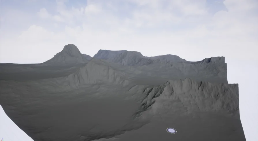
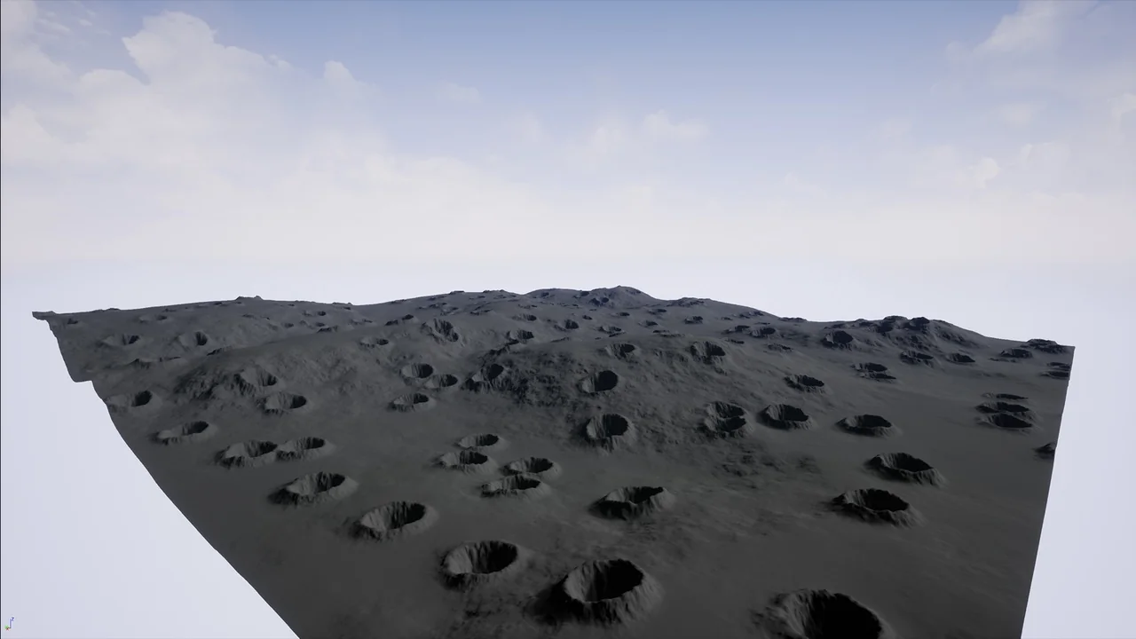
The count is worth spelling out because it tells you what kind of terrain library this actually is. Two canyon maps, six desert, one volcano, five mountains, one erosion, one craters — and further maps beyond those named categories. The total lands at twenty-one.
Six desert maps against five mountain maps is a noticeably dry weighting. Arid ground gets nearly a third of the set, which suits projects where open, sun-lit terrain appears repeatedly and needs variation rather than one hero vista. A single volcano map and a single craters map sit at the opposite end: one distinctive landform each, useful as a set piece rather than a repeatable background.
The canyon pair and the erosion map overlap in intent without duplicating each other. Canyons read as carved channels with defined walls; erosion reads as surface wear, the kind of detail that sits on top of a larger form. Used together, an erosion map can break up a canyon floor that would otherwise look too clean.
Desert, canyon, mountain — the tags behind the terrain types
The vocabulary attached to the pack is short: canyon, desert, mountain, level, hill, erosion. Two of those are workflow words rather than geology. "Level" and "hill" point at how the terrain is meant to be spent — as a base for a playable or explorable space, not as a distant painted backdrop. A hill, in that reading, is a gentler proposition than a mountain: elevation you can walk over rather than elevation that blocks the route.
That framing changes how the set is best approached. Twenty-one maps is more terrain than most single scenes will ever show at once, so the natural pattern is to pick a terrain family per area — a desert stretch, a mountain approach, a canyon crossing — and let the maps within that family do the variation work.
None of this terrain corresponds to real places. The maps are invented, built from imagination rather than surveyed from actual elevation data. There is no real-world location to match them against, and no expectation that a satellite or aerial reference will line up with the shapes. For production, that removes the constraint of geographic accuracy entirely: the terrain serves the scene rather than the other way around. It also means surface texturing, vegetation and rock materials are authored decisions, since nothing in the height data is tied to a specific real biome.
OBJ files that hold the same terrain as geometry
Every height map comes with an OBJ counterpart. The difference is practical rather than cosmetic. A height map is a field of values that a landscape system interprets — it needs a terrain tool to become something you can see. An OBJ is already a mesh.
That gives two entry points into the same terrain. In a modelling application, the OBJ can be rotated, lit and inspected as geometry before any landscape import happens, which makes it useful for judging whether a canyon's proportions suit a shot or whether a mountain's profile reads from a particular angle. In a scene that doesn't run a height-field landscape system at all, the OBJ is the version that works.
Marble Materials compatibility and where the set fits
The pack is compatible with Marble Materials, so terrain built from these maps can be paired with that material set rather than requiring a shader built from scratch. For a team already working in that material pipeline, the terrain and the surfacing side line up without extra bridging work.
In a production flow, height maps at this resolution usually land early — during layout, when the shape of the ground has to be settled before anything is placed on it. A canyon map establishes where a route pinches. A mountain map sets a horizon. A craters map introduces a landmark. Because all twenty-one maps share the same 4096 resolution, swapping one for another during layout doesn't change the technical footing of the scene, only the terrain.
The single erosion map deserves separate mention here. Surface wear is often the last thing added and the first thing that looks wrong when skipped. Having it as a dedicated map means weathered ground can be introduced as its own pass instead of being approximated with noise.
What to settle before committing to the set
The concrete value sits in the pairing: a 4096 grid for terrain shape, an OBJ for the same shape as mesh, and a named material compatibility that removes an unknown from the surfacing stage. Teams weighing the pack should look at the desert-heavy split first — six of twenty-one — and confirm that arid terrain is genuinely what their scenes need, then check which maps fall outside the listed canyon, desert, volcano, mountain, erosion and crater categories. The twenty-one total leaves room there, and knowing what fills it is more useful than the headline count.
 Desert
 Desert
 Desert
 Desert