"c14ff6bd758dadb1"{"id":"1001760","slug":"shrubland-landscape-environment-landscape-arid-landscape-plain-landscape","title":"Shrubland Landscape Environment ( Landscape , Arid Landscape , Plain Landscape )","category":"Desert","engine":"5.3+","assetVersion":"","engineVersion":"Engine Version: 5.3+","tag":"Desert","accent":"blue","visual":"city","summary":"Explore the Shrubland Landscape Environment, featuring a 4x4 km open terrain, photogrammetry rocks, procedural assets, and volumetrics support.","platform":"Unreal Engine","publishedAt":"2026-10-20T03:05:59.117Z","updatedAt":"2026-10-20T03:05:59.117Z","sourceNotes":[],"fileContents":[],"compatibility":["Unreal Engine","Engine Version: 5.3+"],"featuredImage":{"alt":"Shrubland Landscape Environment ( Landscape , Arid Landscape , Plain Landscape )","src":"/wp-content/uploads/published/2026/10/750a34028a5b-2f910fa7-ece2-4e62-aed5-f075f5358d24-1e89d16839.webp"},"hasDownloadLink":true,"downloads":0,"terms":[{"taxonomy":"category","slug":"desert","name":"Desert"}],"galleryImages":[{"src":"/wp-content/uploads/published/2026/10/2f0d025807a8-10444fd9-41bb-4c62-8798-c644a0a27e53-509e3fcee9.webp","alt":"Shrubland Landscape Environment ( Landscape , Arid Landscape , Plain Landscape )"},{"src":"/wp-content/uploads/published/2026/10/834845d25643-18bb48c3-7180-4d52-b845-6b30e9dc6b87-75aa6ed57b.webp","alt":"Shrubland Landscape Environment ( Landscape , Arid Landscape , Plain Landscape )"},{"src":"/wp-content/uploads/published/2026/10/8f44712fb27b-baf9315c-a870-40de-8665-4c3d821461c9-e74992b2aa.webp","alt":"Shrubland Landscape Environment ( Landscape , Arid Landscape , Plain Landscape )"},{"src":"/wp-content/uploads/published/2026/10/8a9e1a6cd643-98c0cd8c-ec34-4143-9b0a-9eaa4eedc1cc-338f183a40.webp","alt":"Shrubland Landscape Environment ( Landscape , Arid Landscape , Plain Landscape )"},{"src":"/wp-content/uploads/published/2026/10/0387aab8b7a1-dabcf9ab-307b-4f6f-80d6-f592d9f92dba-f1df974da5.webp","alt":"Shrubland Landscape Environment ( Landscape , Arid Landscape , Plain Landscape )"},{"src":"/wp-content/uploads/published/2026/10/36a6d19cb868-53b7f509-45c8-4907-9cfb-8462ae453c02-af1510d7c8.webp","alt":"Shrubland Landscape Environment ( Landscape , Arid Landscape , Plain Landscape )"},{"src":"/wp-content/uploads/published/2026/10/182989170300-ff83014f-6f42-4d79-b6a0-3383d3175ebb-f2a21a5de5.webp","alt":"Shrubland Landscape Environment ( Landscape , Arid Landscape , Plain Landscape )"},{"src":"/wp-content/uploads/published/2026/10/c74e359aef51-d5fcfd4e-9991-48ac-94c2-31b132d77c4f-b762de8f35.webp","alt":"Shrubland Landscape Environment ( Landscape , Arid Landscape , Plain Landscape )"},{"src":"/wp-content/uploads/published/2026/10/5e1f476afae3-613f652e-3db7-43a3-86e6-9494f49c5d6d-bf3c931d1f.webp","alt":"Shrubland Landscape Environment ( Landscape , Arid Landscape , Plain Landscape )"}],"accessPanel":{"kind":"resource","title":"Download this resource","eyebrow":"Free Download","message":"Log in or create a free account to start your download.","fileName":"Content.7z","safetyNote":"Resources are manually reviewed before listing to improve quality and reduce obvious risks.","actionLabel":"Download Free","resourceType":"Resource archive"},"contentHtml":"\u003ch2\u003eThe 4x4 km Shrubland Terrain and Procedural Landscape Assets\u003c/h2\u003e\u003cp\u003eShrubland Landscape Environment is centered around a massive 4x4 kilometer terrain designed to balance expansive geographic scale with modular flexibility. At its foundation, the package provides a complete, ready-to-run environment alongside procedurally generated landscape assets that automate the distribution of natural surface details. Creators are not restricted to using the pre-assembled layout as an immutable backdrop; the package is structured so that developers can build custom shrubland landscape maps entirely from scratch, utilizing the included terrain rules and asset distributions to populate new regions quickly.\u003c/p\u003e\u003cp\u003eThe procedural distribution handles vast areas where manual placement would prove impractical. Spanning four continuous kilometers in both width and length, the map establishes rolling topography characteristic of semi-arid shrublands and open plain environments. Ground cover, soil variations, and low-lying vegetation populate according to procedural logic, allowing terrain modifications without breaking the environmental coherence of the biome. Whether reshaping mountain contours or carving out new valleys, the procedural elements adapt to newly sculpted heightmaps, ensuring that plant life, rocks, and surface transitions remain naturally placed across the entire landmass.\u003c/p\u003e\u003ch2\u003eRock and Foliage Photogrammetry Assets Across Arid and Plain Formations\u003c/h2\u003e\u003cp\u003eGeological and botanical assets form the visual core of this environment, relying on photogrammetry-derived data and high-fidelity reference photography to ground the scene in reality. The plant selection focuses heavily on realistic shrubs, bushes, and scattered trees typical of hardy, windswept plains. Rather than presenting lush, dense forest canopies, the vegetation reflects an authentic arid profile, featuring low-lying brush, resilient shrubs, and dry-climate flora distributed sparsely across the dirt, rock, and mountain slopes.\u003c/p\u003e\u003cp\u003eComplementing the plant life is a comprehensive set of geological formations. The package incorporates detailed rocks, steep cliff faces, and dramatic canyon geometry that define natural elevation changes across the 4x4 km map. Detailed textures support both long-distance mountain silhouettes and close-up rocky shelves. Coastal edges, canyon passes, and sharp cliff drop-offs provide clear physical boundaries and focal points within the landscape. Because the assets originate from photogrammetry references, surface micro-details on boulders, stone outcrops, and cracked earth layers blend together seamlessly, preventing visual repetition across large expanses of wilderness.\u003c/p\u003e\u003ch2\u003eVolumetrics Plugin Setup and Render Fidelity Settings\u003c/h2\u003e\u003cp\u003eAtmospheric density and lighting play an essential role in realizing the open-world scale of the package. To display the demo map as intended, users must enable the built-in Volumetrics plugin directly from the engine's Plugins menu. Activating this system ensures that atmospheric fog, horizon hazes, and light scattering across mountain ridges compute properly. Without the Volumetrics plugin engaged, the environmental lighting lacks the realistic depth required to convey true four-kilometer distances, causing distant canyons and mountain silhouettes to lose their atmospheric layering.\u003c/p\u003e\u003cp\u003eFor those capturing cinematic sequences or high-resolution marketing imagery, visual fidelity can be elevated further through an engine command adjustment. Setting the screen percentage to 200 matches the refined output showcased in the cinematic trailers and speed-level demonstration footage. Increasing this value forces the engine to render the scene at double the standard viewport resolution before scaling, which smooths out sub-pixel foliage edges, refines shadow boundaries across procedural grass and shrub meshes, and sharpens fine rock textures. While standard render scales remain gameready for real-time interaction, pushing the screen percentage to 200 extracts peak detail from the photogrammetry assets during still renders and cinematic video passes.\u003c/p\u003e\u003ch2\u003eGameready Level Design for Outpost, Warfare, and Industrial Integration\u003c/h2\u003e\u003cp\u003eThe package includes a dedicated ThirdPersonDemo configuration, allowing teams to drop directly into the map to evaluate scale, player locomotion, and collision handling across irregular terrain. Navigation across rugged canyons, brush-covered plains, and steep rock formations can be tested immediately with standard third-person mechanics. Because the layout is optimized for gameready performance, the environment works as an operational foundation for military warfare scenarios, border outposts, simulation projects, and virtual production scenes requiring realistic exterior staging.\u003c/p\u003e\u003cp\u003eThe dry, open nature of the terrain also enables smooth crossover integration with industrial asset sets. The Shrubland Landscape Environment is compatible with the Chemical Plant \u0026amp; Refinery Environment, allowing developers to blend industrial factory complexes, processing units, and refinery buildings directly into the arid wilderness. Placing heavy manufacturing facilities or remote desert compounds within the canyon valleys or wide-open plains creates immediate visual storytelling, framing utilitarian industrial architecture against an untamed, sun-drenched landscape.\u003c/p\u003e\u003ch2\u003eWorkflow Applications for Plain and Arid Landscape Production\u003c/h2\u003e\u003cp\u003eDeveloping open-world exteriors often requires balancing massive geographic footprints with fine-grained visual interest. This package addresses that challenge by combining wide-area procedural tools with high-detail rock and bush models that hold up under direct scrutiny. The expansive 4x4 km boundary gives level designers sufficient room to establish separated gameplay zones, distinct combat arenas, or extended vehicle routes without encountering artificial world boundaries.\u003c/p\u003e\u003cp\u003eFrom isolated coastal cliffs to expansive inland plains and rugged canyon networks, the environment provides the essential physical elements needed to construct varied arid zones. Whether utilized as a turn-key backdrop for fast-paced warfare simulations or leveraged as a procedural toolkit for crafting custom scrubland biomes from scratch, the included assets provide the technical framework necessary to realize large-scale natural environments.\u003c/p\u003e\n\n\u003ch2\u003eExplore Similar Assets\u003c/h2\u003e\n\u003cul\u003e\n\u003cli\u003e\u003ca href=\"https://3dcghub.com/photorealistic-landscape-bundle-1/\" title=\"Photorealistic Landscape Bundle 1\"\u003ePhotorealistic Landscape Bundle 1\u003c/a\u003e\u003c/li\u003e\n\u003cli\u003e\u003ca href=\"https://3dcghub.com/desert-oasis/\" title=\"Desert Oasis\"\u003eDesert Oasis\u003c/a\u003e\u003c/li\u003e\n\u003cli\u003e\u003ca href=\"https://3dcghub.com/landscape-procedural-desert-sandstorm/\" title=\"Landscape Procedural Desert - Sandstorm\"\u003eLandscape Procedural Desert - Sandstorm\u003c/a\u003e\u003c/li\u003e\n\u003cli\u003e\u003ca href=\"https://3dcghub.com/ancient-desert-ruins-environment-w-map-generator-pcg/\" title=\"Ancient Desert Ruins Environment w/ Map Generator PCG\"\u003eAncient Desert Ruins Environment w/ Map Generator PCG\u003c/a\u003e\u003c/li\u003e\n\u003cli\u003e\u003ca href=\"https://3dcghub.com/mw-shrubs-bushes-biome/\" title=\"MW Shrubs \u0026amp; Bushes Biome\"\u003eMW Shrubs \u0026amp; Bushes Biome\u003c/a\u003e\u003c/li\u003e\n\u003c/ul\u003e","contentTextLength":6517,"navigation":{"current":23,"total":3719,"previous":{"id":"1001761","slug":"space-scenes","title":"Space Scenes","category":"Sky \u0026 Space","platform":"Unreal Engine","updatedAt":"2026-10-20T03:07:34.480Z"},"next":{"id":"1001759","slug":"scifi-military-car","title":"SciFi Military Car","category":"Military","platform":"Unreal Engine","updatedAt":"2026-10-20T03:05:07.620Z"}},"relatedResources":[{"id":"7797","slug":"photorealistic-landscape-bundle-1","title":"Photorealistic Landscape Bundle 1","category":"Desert","engine":"4.26+,5.0+","assetVersion":"Engine version: 4.26+,5.0+","engineVersion":"4.13","tag":"Desert","accent":"blue","visual":"city","summary":"Enhance your digital worlds with the Photorealistic Landscape Bundle 1. This collection features 14 diverse terrains ranging from icy plains to desert canyons, perfect for any open-world project.","platform":"Unreal Engine","publishedAt":"2026-02-21T17:50:17.000Z","updatedAt":"2026-04-19T15:55:55.000Z","sourceNotes":[],"fileContents":[],"compatibility":["Unreal Engine","Engine version: 4.26+,5.0+"],"featuredImage":{"alt":"Photorealistic Landscape Bundle 1","src":"https://3dcghub.com/wp-content/uploads/2026/02/3ff97797-eac7-4c2e-bec4-14c725103e37.webp"},"hasDownloadLink":true,"downloads":0},{"id":"1000117","slug":"desert-oasis","title":"Desert Oasis","category":"Desert","engine":"4.26+,5.0+","assetVersion":"","engineVersion":"Engine Version: 4.26+,5.0+","tag":"Desert","accent":"blue","visual":"mech","summary":"Build immersive arid environments with the Desert Oasis pack, featuring over 100 handcrafted meshes, advanced landscape tools, and dynamic sand effects.","platform":"Unreal Engine","publishedAt":"2026-06-09T14:40:55.104Z","updatedAt":"2026-06-09T14:40:55.104Z","sourceNotes":[],"fileContents":[],"compatibility":["Unreal Engine","Engine Version: 4.26+,5.0+"],"featuredImage":{"alt":"Desert Oasis","src":"/wp-content/uploads/published/2026/06/b552b02194f5-b7cec64b-d087-453f-ab9e-e061287f5a86-7112d9f5ce.webp"},"hasDownloadLink":true,"downloads":1},{"id":"1000231","slug":"landscape-procedural-desert-sandstorm","title":"Landscape Procedural Desert - Sandstorm","category":"Desert","engine":"5.0+","assetVersion":"","engineVersion":"Engine Version: 5.0+","tag":"Desert","accent":"blue","visual":"city","summary":"Generate massive open-world desert landscapes in under 10 minutes using a 12-layer auto-material, procedural foliage spawners, and player-attached sandstorm VFX","platform":"Unreal Engine","publishedAt":"2026-06-28T07:21:47.532Z","updatedAt":"2026-06-28T07:21:47.532Z","sourceNotes":[],"fileContents":[],"compatibility":["Unreal Engine","Engine Version: 5.0+"],"featuredImage":{"alt":"Landscape Procedural Desert - Sandstorm","src":"/wp-content/uploads/published/2026/06/a73f7d583dbc-1031ec2f-55e0-4db1-b4d5-a7a312b642f3-e5533e3ac9.webp"},"hasDownloadLink":true,"downloads":1}]}
Explore the Shrubland Landscape Environment, featuring a 4x4 km open terrain, photogrammetry rocks, procedural assets, and volumetrics support.
Category:Unreal Engine,DesertPlatform: Unreal EngineEngine Version: 5.3+Published: Oct 20, 2026
Desert
Resource overview
The 4x4 km Shrubland Terrain and Procedural Landscape Assets
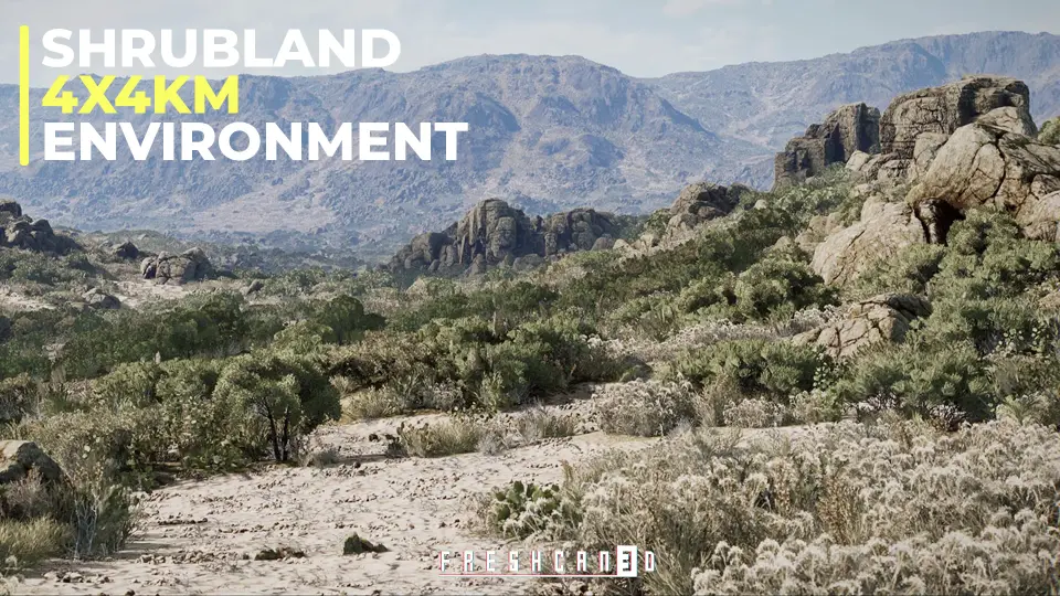
Shrubland Landscape Environment is centered around a massive 4x4 kilometer terrain designed to balance expansive geographic scale with modular flexibility. At its foundation, the package provides a complete, ready-to-run environment alongside procedurally generated landscape assets that automate the distribution of natural surface details. Creators are not restricted to using the pre-assembled layout as an immutable backdrop; the package is structured so that developers can build custom shrubland landscape maps entirely from scratch, utilizing the included terrain rules and asset distributions to populate new regions quickly.
The procedural distribution handles vast areas where manual placement would prove impractical. Spanning four continuous kilometers in both width and length, the map establishes rolling topography characteristic of semi-arid shrublands and open plain environments. Ground cover, soil variations, and low-lying vegetation populate according to procedural logic, allowing terrain modifications without breaking the environmental coherence of the biome. Whether reshaping mountain contours or carving out new valleys, the procedural elements adapt to newly sculpted heightmaps, ensuring that plant life, rocks, and surface transitions remain naturally placed across the entire landmass.
Rock and Foliage Photogrammetry Assets Across Arid and Plain Formations
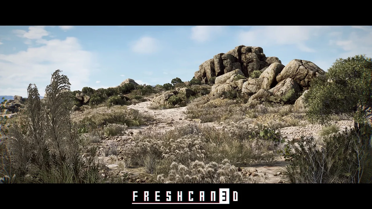
Geological and botanical assets form the visual core of this environment, relying on photogrammetry-derived data and high-fidelity reference photography to ground the scene in reality. The plant selection focuses heavily on realistic shrubs, bushes, and scattered trees typical of hardy, windswept plains. Rather than presenting lush, dense forest canopies, the vegetation reflects an authentic arid profile, featuring low-lying brush, resilient shrubs, and dry-climate flora distributed sparsely across the dirt, rock, and mountain slopes.
Complementing the plant life is a comprehensive set of geological formations. The package incorporates detailed rocks, steep cliff faces, and dramatic canyon geometry that define natural elevation changes across the 4x4 km map. Detailed textures support both long-distance mountain silhouettes and close-up rocky shelves. Coastal edges, canyon passes, and sharp cliff drop-offs provide clear physical boundaries and focal points within the landscape. Because the assets originate from photogrammetry references, surface micro-details on boulders, stone outcrops, and cracked earth layers blend together seamlessly, preventing visual repetition across large expanses of wilderness.
Volumetrics Plugin Setup and Render Fidelity Settings
Atmospheric density and lighting play an essential role in realizing the open-world scale of the package. To display the demo map as intended, users must enable the built-in Volumetrics plugin directly from the engine's Plugins menu. Activating this system ensures that atmospheric fog, horizon hazes, and light scattering across mountain ridges compute properly. Without the Volumetrics plugin engaged, the environmental lighting lacks the realistic depth required to convey true four-kilometer distances, causing distant canyons and mountain silhouettes to lose their atmospheric layering.
For those capturing cinematic sequences or high-resolution marketing imagery, visual fidelity can be elevated further through an engine command adjustment. Setting the screen percentage to 200 matches the refined output showcased in the cinematic trailers and speed-level demonstration footage. Increasing this value forces the engine to render the scene at double the standard viewport resolution before scaling, which smooths out sub-pixel foliage edges, refines shadow boundaries across procedural grass and shrub meshes, and sharpens fine rock textures. While standard render scales remain gameready for real-time interaction, pushing the screen percentage to 200 extracts peak detail from the photogrammetry assets during still renders and cinematic video passes.
Gameready Level Design for Outpost, Warfare, and Industrial Integration
The package includes a dedicated ThirdPersonDemo configuration, allowing teams to drop directly into the map to evaluate scale, player locomotion, and collision handling across irregular terrain. Navigation across rugged canyons, brush-covered plains, and steep rock formations can be tested immediately with standard third-person mechanics. Because the layout is optimized for gameready performance, the environment works as an operational foundation for military warfare scenarios, border outposts, simulation projects, and virtual production scenes requiring realistic exterior staging.
The dry, open nature of the terrain also enables smooth crossover integration with industrial asset sets. The Shrubland Landscape Environment is compatible with the Chemical Plant & Refinery Environment, allowing developers to blend industrial factory complexes, processing units, and refinery buildings directly into the arid wilderness. Placing heavy manufacturing facilities or remote desert compounds within the canyon valleys or wide-open plains creates immediate visual storytelling, framing utilitarian industrial architecture against an untamed, sun-drenched landscape.
Workflow Applications for Plain and Arid Landscape Production
Developing open-world exteriors often requires balancing massive geographic footprints with fine-grained visual interest. This package addresses that challenge by combining wide-area procedural tools with high-detail rock and bush models that hold up under direct scrutiny. The expansive 4x4 km boundary gives level designers sufficient room to establish separated gameplay zones, distinct combat arenas, or extended vehicle routes without encountering artificial world boundaries.
From isolated coastal cliffs to expansive inland plains and rugged canyon networks, the environment provides the essential physical elements needed to construct varied arid zones. Whether utilized as a turn-key backdrop for fast-paced warfare simulations or leveraged as a procedural toolkit for crafting custom scrubland biomes from scratch, the included assets provide the technical framework necessary to realize large-scale natural environments.
 Desert
 Desert
 Desert
 Desert