"a19e0535960bd083"{"id":"1002067","slug":"japan-mount-fuji","title":"Japan Mount Fuji","category":"Mountain","engine":"4.26+,5.0+","assetVersion":"","engineVersion":"Engine Version: 4.26+,5.0+","tag":"Mountain","accent":"blue","visual":"mech","summary":"Japan Mount Fuji provides real-world terrain generated from satellite digital elevation models for interactive games and travel virtual reality scenes.","platform":"Unreal Engine","publishedAt":"2026-10-26T15:29:58.677Z","updatedAt":"2026-10-26T15:29:58.677Z","sourceNotes":[],"fileContents":[],"compatibility":["Unreal Engine","Engine Version: 4.26+,5.0+"],"featuredImage":{"alt":"Japan Mount Fuji","src":"/wp-content/uploads/published/2026/10/1505b7bb246b-3ac50083-67b0-441a-a2d7-cdce52614236-5d99529d10.webp"},"hasDownloadLink":true,"downloads":0,"terms":[{"taxonomy":"category","slug":"mountain","name":"Mountain"}],"galleryImages":[{"src":"/wp-content/uploads/published/2026/10/a19fccd9e6c1-4d511fec-a1ed-426f-98e9-f4078335967b-f55318b1a6.webp","alt":"Japan Mount Fuji"},{"src":"/wp-content/uploads/published/2026/10/c6909b444f26-c76b947a-0b88-4d5b-88bd-8478d2f6d33b-afec06bba3.webp","alt":"Japan Mount Fuji"},{"src":"/wp-content/uploads/published/2026/10/d35538869697-6e8f922c-1b06-4089-9a82-86b7201160ca-31a388186c.webp","alt":"Japan Mount Fuji"},{"src":"/wp-content/uploads/published/2026/10/05c184657bf5-633f52be-5f11-4416-933c-377c5235c061-b9f26ff2bc.webp","alt":"Japan Mount Fuji"},{"src":"/wp-content/uploads/published/2026/10/4a199f4b6fc0-1df06fdd-e501-4e59-a0c4-1df7b5ac1704-cc655cb0c0.webp","alt":"Japan Mount Fuji"},{"src":"/wp-content/uploads/published/2026/10/ead40f776f46-52678a5d-780c-4fe2-a515-94b6ee239b94-d3c34ad272.webp","alt":"Japan Mount Fuji"},{"src":"/wp-content/uploads/published/2026/10/1dbc9c3adb9f-ec1a8bf2-4a1c-4809-a739-ffbad05b19c0-2fe3edf881.webp","alt":"Japan Mount Fuji"},{"src":"/wp-content/uploads/published/2026/10/34cf081e74d5-3c3ca90a-d53b-4835-aa5b-171c67d44d15-3ec4732382.webp","alt":"Japan Mount Fuji"}],"accessPanel":{"kind":"resource","title":"Download this resource","eyebrow":"Free Download","message":"Log in or create a free account to start your download.","fileName":"Content.7z","safetyNote":"Resources are manually reviewed before listing to improve quality and reduce obvious risks.","actionLabel":"Download Free","resourceType":"Resource archive"},"contentHtml":"\u003ch2\u003eIntegrating Japan Mount Fuji Terrain into Real-Time Levels\u003c/h2\u003e\n\u003cp\u003eDeploying large-scale geographic features into an interactive level begins with establishing physical scale and surface contouring. Japan Mount Fuji introduces a terrain foundation derived directly from a satellite digital elevation model. Rather than relying on stylized heightmaps or artist-sculpted peaks, the geometry originates from satellite elevation scans, providing an accurate recreation of the iconic volcano and its surrounding landforms.\u003c/p\u003e\n\u003cp\u003eIn production pipelines, bringing this landscape into an engine or staging environment allows world builders to establish immediate horizon profiles. Terrain generated from satellite data inherently carries the subtle slope transitions, ridge lines, and base gradations that define real-world geological structures. Using such data bypasses the lengthy initial sculpting phases needed to balance realistic scale and elevation drop-offs. Creators can stage the terrain as a walkable level layout or set it along the periphery as distant background scenery.\u003c/p\u003e \u003ch2\u003eSatellite Digital Elevation Model Topography and Mountain Scale\u003c/h2\u003e\n\u003cp\u003eThe defining technical characteristic of Japan Mount Fuji is its reliance on a satellite digital elevation model. Elevation models capture the vertical height values of natural landscapes across precise geographic coordinates. In real-time rendering, this means the tapering stratovolcano profile of Mount Fuji retains authentic geometric proportions, from the broad base spreading outward into the lowlands up to the steep inclines near the summit.\u003c/p\u003e\n\u003cp\u003eReal-world topography presents distinct design advantages. Hand-sculpted mountains often suffer from repetitive brush strokes, unnatural plateauing, or inconsistent slope angles that break immersion when viewed from multiple elevations. Because this terrain is formed from satellite elevation measurements, the macro-structure exhibits authentic drainage channels, natural erosion creases, and genuine slope curvature. Whether the camera sits miles away across a valley or tracks along the lower foothills, the silhouette maintains the recognizable proportions of the landmark.\u003c/p\u003e \u003ch2\u003eDeployment in Games and Travel Virtual Reality Scenes\u003c/h2\u003e\n\u003cp\u003eApplication paths for this landscape center on interactive game development and travel-oriented virtual reality experiences. Each use case approaches the terrain from a different perspective and requires distinct layout priorities:\u003c/p\u003e\n\u003cul\u003e \u003cli\u003e\u003cstrong\u003eTravel Virtual Reality Scenes:\u003c/strong\u003e Immersive VR simulations demand accurate scale perception. Because users observe environments with natural stereoscopic depth, artificial or incorrectly proportioned terrains quickly feel miniature or unnatural. Placing the viewer within a virtual reality scene based on an authentic digital elevation model ensures that the visual mass and towering presence of the mountain translate accurately to head-mounted displays.\u003c/li\u003e \u003cli\u003e\u003cstrong\u003eInteractive Game Levels:\u003c/strong\u003e Game production often requires massive vistas to establish a distinct sense of place. Japan Mount Fuji functions both as playable ground terrain and as high-visibility landmark scenery. Level designers can establish traversal paths across the slopes or position the peak as a permanent navigation beacon visible from almost anywhere within the surrounding map area.\u003c/li\u003e \u003cli\u003e\u003cstrong\u003eSimulated Flight and Fly-Through Sequences:\u003c/strong\u003e The vast footprint of a regional elevation model provides the necessary surface area for flight simulations, aerial tourism paths, or cinematic establishing shots that require sustained views over continuous terrain without encountering artificial map boundaries prematurely.\u003c/li\u003e\n\u003c/ul\u003e \u003ch2\u003eEnvironment Structuring and Guilin Karst Landscape Compatibility\u003c/h2\u003e\n\u003cp\u003eWhen assembling regional terrain libraries for production environments, pairing complementary assets ensures consistency across world building workflows. Japan Mount Fuji maintains workflow compatibility with assets such as the Guilin Karst Landscape. Combining or organizing these landscapes within a single production framework allows developers to alternate between diverse Asian geological features, contrasting the solitary volcanic rise of Mount Fuji with the jagged, weathered towers characteristic of karst topography.\u003c/p\u003e\n\u003cp\u003eIn multi-level projects or multi-region simulation hubs, maintaining compatible terrain setups streamlines environment lighting, atmospheric fog tuning, and distant horizon matching. Having distinct geographic archetypes built upon digital elevation principles allows teams to construct contrasting environments—transitioning from the wide volcanic plains of Japan to the vertical spires of karst geography—without redesigning base landscape shaders or camera clipping settings.\u003c/p\u003e \u003ch2\u003eProduction Considerations for Elevation-Based Terrain Levels\u003c/h2\u003e\n\u003cp\u003eWorking effectively with digital elevation terrain requires careful management of camera distances, level bounds, and visual density. Because the core geometry is fixed to the contours of the real-world mountain, secondary environment dressing must complement the natural topology rather than fight it. Road networks, hiking trails, building structures, and foliage systems must align smoothly against the slopes captured by the elevation model.\u003c/p\u003e\n\u003cp\u003eFor virtual reality tourism, user placement should prioritize viewing clear angles of the summit and expansive lowlands to maximize the feeling of scale. In gameplay applications, boundaries can be formed naturally by utilizing the steep upper elevations of the peak or the outward edges of the captured terrain tile. Staging the asset as a complete level or as background scenery provides immediate geographical credibility, anchoring projects with the authentic scale and presence of one of the world's most recognized mountains.\u003c/p\u003e\n\n\u003ch2\u003eRelated Resources Worth Checking\u003c/h2\u003e\n\u003cul\u003e\n\u003cli\u003e\u003ca href=\"https://3dcghub.com/mountain-ancient-mountain-mount-shrine-mountain-environment/\" title=\"Mountain (Ancient Mountain, Mount, Shrine, Mountain Environment)\"\u003eMountain (Ancient Mountain, Mount, Shrine, Mountain Environment)\u003c/a\u003e\u003c/li\u003e\n\u003cli\u003e\u003ca href=\"https://3dcghub.com/brushify-floating-islands/\" title=\"Brushify - Floating Islands\"\u003eBrushify - Floating Islands\u003c/a\u003e\u003c/li\u003e\n\u003cli\u003e\u003ca href=\"https://3dcghub.com/eastern-iceland-landscape/\" title=\"Eastern Iceland Landscape\"\u003eEastern Iceland Landscape\u003c/a\u003e\u003c/li\u003e\n\u003cli\u003e\u003ca href=\"https://3dcghub.com/snow-forest/\" title=\"Snow Forest\"\u003eSnow Forest\u003c/a\u003e\u003c/li\u003e\n\u003cli\u003e\u003ca href=\"https://3dcghub.com/brushify-grasslands-pack/\" title=\"Brushify - Grasslands Pack\"\u003eBrushify - Grasslands Pack\u003c/a\u003e\u003c/li\u003e\n\u003c/ul\u003e","contentTextLength":5908,"navigation":{"current":24,"total":4026,"previous":{"id":"1002068","slug":"just-whoosh-2","title":"Just Whoosh 2","category":"Sound Effects","platform":"Unreal Engine","updatedAt":"2026-10-26T15:30:26.924Z"},"next":{"id":"1002066","slug":"item-and-consumable-animations","title":"Item \u0026 Consumable Animations","category":"Variety","platform":"Unreal Engine","updatedAt":"2026-10-26T15:25:52.277Z"}},"relatedResources":[{"id":"9387","slug":"mountain-ancient-mountain-mount-shrine-mountain-environment","title":"Mountain (Ancient Mountain, Mount, Shrine, Mountain Environment)","category":"Mountain","engine":"5.0+","assetVersion":"Engine version: 5.0+","engineVersion":"5.0","tag":"Mountain","accent":"blue","visual":"city","summary":"Build massive ancient cities and mystical shrines using this comprehensive asset pack. It features 74 unique meshes, a large foliage library, and advanced visual effects for Unreal Engine 5.","platform":"Unreal Engine","publishedAt":"2026-03-01T16:44:56.000Z","updatedAt":"2026-04-19T15:51:14.000Z","sourceNotes":[],"fileContents":[],"compatibility":["Unreal Engine","Engine version: 5.0+"],"featuredImage":{"alt":"Mountain (Ancient Mountain, Mount, Shrine, Mountain Environment)","src":"https://3dcghub.com/wp-content/uploads/2026/03/5da8ed27-2fbb-4fef-a0b5-9c0618be1e48.webp"},"hasDownloadLink":true,"downloads":0},{"id":"1001396","slug":"brushify-floating-islands","title":"Brushify - Floating Islands","category":"Mountain","engine":"4.26+,5.0+","assetVersion":"","engineVersion":"Engine Version: 4.26+,5.0+","tag":"Mountain","accent":"blue","visual":"mech","summary":"Build suspended fantasy and alien terrains in Unreal Engine 5 using Brushify - Floating Islands, featuring modular prefabs and an auto landscape material.","platform":"Unreal Engine","publishedAt":"2026-10-04T17:50:49.947Z","updatedAt":"2026-10-04T17:50:49.947Z","sourceNotes":[],"fileContents":[],"compatibility":["Unreal Engine","Engine Version: 4.26+,5.0+"],"featuredImage":{"alt":"Brushify - Floating Islands","src":"/wp-content/uploads/published/2026/10/97bf9d1cfb82-0c60deb5-50e3-43cf-ba20-c0da89d406a6-4050f9c2e1.webp"},"hasDownloadLink":true,"downloads":1},{"id":"1001136","slug":"eastern-iceland-landscape","title":"Eastern Iceland Landscape","category":"Mountain","engine":"4.26+,5.0+","assetVersion":"","engineVersion":"Engine Version: 4.26+,5.0+","tag":"Mountain","accent":"blue","visual":"city","summary":"A 64 square kilometer terrain with 1x1 m vertex density, volumetric 3D clouds, dynamic cloud shadows, and layered material controls for realistic outdoor scenes","platform":"Unreal Engine","publishedAt":"2026-09-09T03:20:31.567Z","updatedAt":"2026-09-09T03:20:31.567Z","sourceNotes":[],"fileContents":[],"compatibility":["Unreal Engine","Engine Version: 4.26+,5.0+"],"featuredImage":{"alt":"Eastern Iceland Landscape","src":"/wp-content/uploads/published/2026/09/ffd4b4699908-7793c3ec-35c9-4cc6-b06d-962d5f6ccb4e-89f3513491.webp"},"hasDownloadLink":true,"downloads":1}]}
Mountain
Japan Mount Fuji
Japan Mount Fuji provides real-world terrain generated from satellite digital elevation models for interactive games and travel virtual reality scenes.
Category:Unreal Engine,MountainPlatform: Unreal EngineEngine Version: 4.26+,5.0+Published: Oct 26, 2026
Mountain
Resource overview
Integrating Japan Mount Fuji Terrain into Real-Time Levels
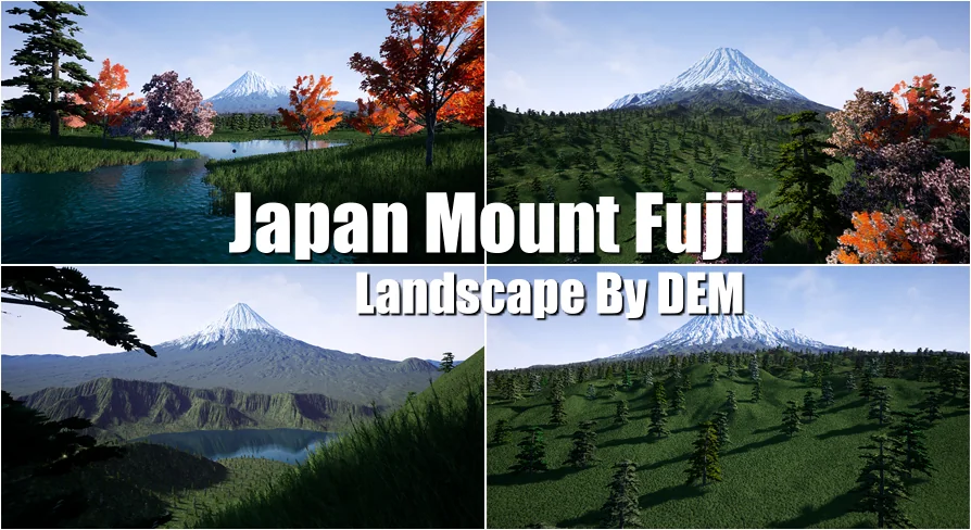
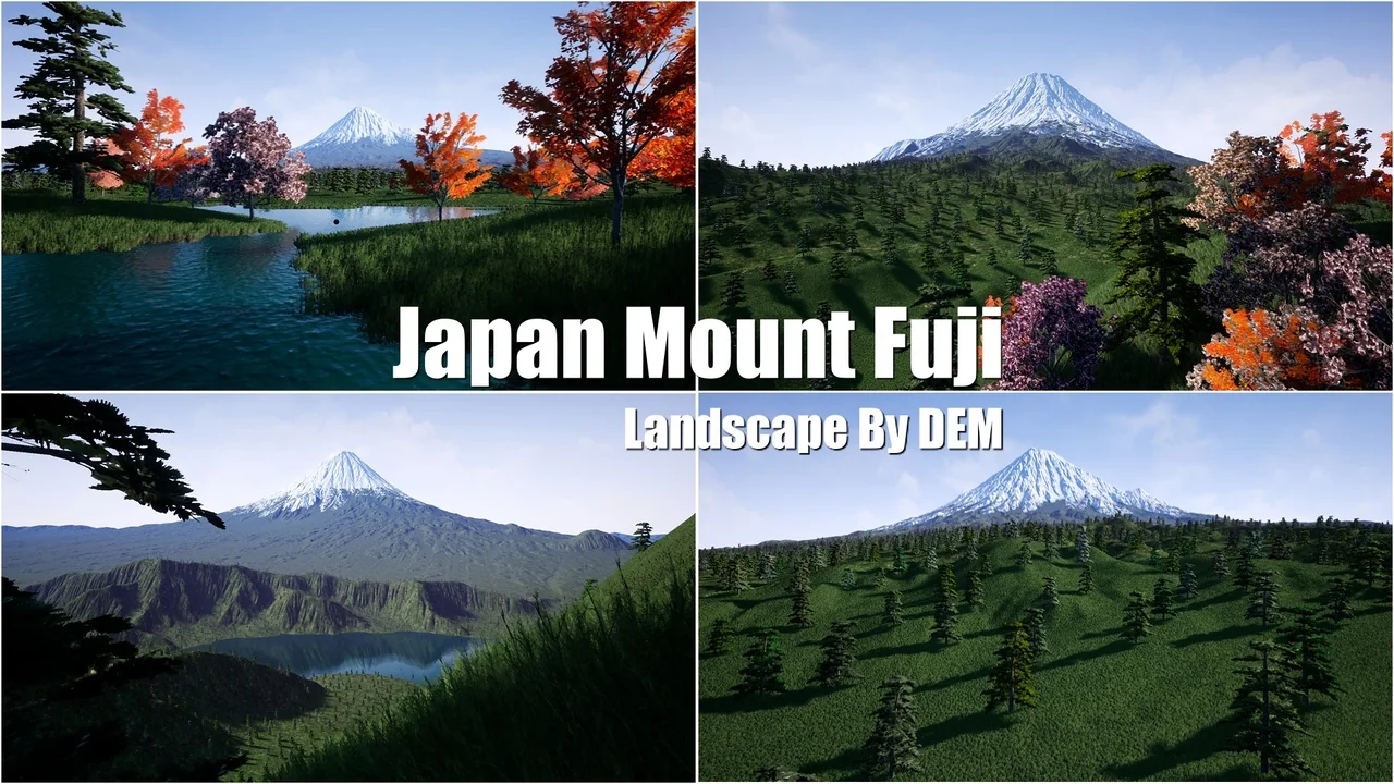
Deploying large-scale geographic features into an interactive level begins with establishing physical scale and surface contouring. Japan Mount Fuji introduces a terrain foundation derived directly from a satellite digital elevation model. Rather than relying on stylized heightmaps or artist-sculpted peaks, the geometry originates from satellite elevation scans, providing an accurate recreation of the iconic volcano and its surrounding landforms.
In production pipelines, bringing this landscape into an engine or staging environment allows world builders to establish immediate horizon profiles. Terrain generated from satellite data inherently carries the subtle slope transitions, ridge lines, and base gradations that define real-world geological structures. Using such data bypasses the lengthy initial sculpting phases needed to balance realistic scale and elevation drop-offs. Creators can stage the terrain as a walkable level layout or set it along the periphery as distant background scenery.
Satellite Digital Elevation Model Topography and Mountain Scale
The defining technical characteristic of Japan Mount Fuji is its reliance on a satellite digital elevation model. Elevation models capture the vertical height values of natural landscapes across precise geographic coordinates. In real-time rendering, this means the tapering stratovolcano profile of Mount Fuji retains authentic geometric proportions, from the broad base spreading outward into the lowlands up to the steep inclines near the summit.
Real-world topography presents distinct design advantages. Hand-sculpted mountains often suffer from repetitive brush strokes, unnatural plateauing, or inconsistent slope angles that break immersion when viewed from multiple elevations. Because this terrain is formed from satellite elevation measurements, the macro-structure exhibits authentic drainage channels, natural erosion creases, and genuine slope curvature. Whether the camera sits miles away across a valley or tracks along the lower foothills, the silhouette maintains the recognizable proportions of the landmark.
Deployment in Games and Travel Virtual Reality Scenes
Application paths for this landscape center on interactive game development and travel-oriented virtual reality experiences. Each use case approaches the terrain from a different perspective and requires distinct layout priorities:
Travel Virtual Reality Scenes: Immersive VR simulations demand accurate scale perception. Because users observe environments with natural stereoscopic depth, artificial or incorrectly proportioned terrains quickly feel miniature or unnatural. Placing the viewer within a virtual reality scene based on an authentic digital elevation model ensures that the visual mass and towering presence of the mountain translate accurately to head-mounted displays.
Interactive Game Levels: Game production often requires massive vistas to establish a distinct sense of place. Japan Mount Fuji functions both as playable ground terrain and as high-visibility landmark scenery. Level designers can establish traversal paths across the slopes or position the peak as a permanent navigation beacon visible from almost anywhere within the surrounding map area.
Simulated Flight and Fly-Through Sequences: The vast footprint of a regional elevation model provides the necessary surface area for flight simulations, aerial tourism paths, or cinematic establishing shots that require sustained views over continuous terrain without encountering artificial map boundaries prematurely.
Environment Structuring and Guilin Karst Landscape Compatibility
When assembling regional terrain libraries for production environments, pairing complementary assets ensures consistency across world building workflows. Japan Mount Fuji maintains workflow compatibility with assets such as the Guilin Karst Landscape. Combining or organizing these landscapes within a single production framework allows developers to alternate between diverse Asian geological features, contrasting the solitary volcanic rise of Mount Fuji with the jagged, weathered towers characteristic of karst topography.
In multi-level projects or multi-region simulation hubs, maintaining compatible terrain setups streamlines environment lighting, atmospheric fog tuning, and distant horizon matching. Having distinct geographic archetypes built upon digital elevation principles allows teams to construct contrasting environments—transitioning from the wide volcanic plains of Japan to the vertical spires of karst geography—without redesigning base landscape shaders or camera clipping settings.
Production Considerations for Elevation-Based Terrain Levels
Working effectively with digital elevation terrain requires careful management of camera distances, level bounds, and visual density. Because the core geometry is fixed to the contours of the real-world mountain, secondary environment dressing must complement the natural topology rather than fight it. Road networks, hiking trails, building structures, and foliage systems must align smoothly against the slopes captured by the elevation model.
For virtual reality tourism, user placement should prioritize viewing clear angles of the summit and expansive lowlands to maximize the feeling of scale. In gameplay applications, boundaries can be formed naturally by utilizing the steep upper elevations of the peak or the outward edges of the captured terrain tile. Staging the asset as a complete level or as background scenery provides immediate geographical credibility, anchoring projects with the authentic scale and presence of one of the world's most recognized mountains.
 Mountain
 Mountain
 Mountain
 Mountain