"7aa4acc705f0d80b"{"id":"1001982","slug":"coala-map-plugin-with-real-world-integration","title":"COALA - Map Plugin With Real World Integration","category":"Engine Tools","engine":"5.3","assetVersion":"Asset Version: 0.2.12","engineVersion":"Engine Version: 5.3","tag":"Engine Tools","accent":"blue","visual":"mech","summary":"Explore the COALA map plugin for integrating real-world GPS, streets, weather, grid terrains, and live context data into interactive projects.","platform":"Unreal Engine","publishedAt":"2026-10-24T14:27:56.281Z","updatedAt":"2026-10-24T14:27:56.281Z","sourceNotes":[],"fileContents":[],"compatibility":["Unreal Engine","Asset Version: 0.2.12","Engine Version: 5.3"],"featuredImage":{"alt":"COALA - Map Plugin With Real World Integration","src":"/wp-content/uploads/published/2026/10/a421c1833bd8-5ec2563d-2ed5-4333-a2fe-ec448fd11b3f-13255aafb4.webp"},"hasDownloadLink":true,"downloads":0,"terms":[{"taxonomy":"category","slug":"engine-tools-tools-and-plugins","name":"Engine Tools"}],"galleryImages":[{"src":"/wp-content/uploads/published/2026/10/2ecc2f1da687-2b3375d7-e1f0-4ba5-acc4-c184db1b98f9-467efdbf16.webp","alt":"COALA - Map Plugin With Real World Integration"},{"src":"/wp-content/uploads/published/2026/10/6a2d7dad36f8-c0224477-700e-4b87-8120-28ac816d8b8a-cef37c5bfd.webp","alt":"COALA - Map Plugin With Real World Integration"},{"src":"/wp-content/uploads/published/2026/10/86dd50293971-a2b79a6c-f8a3-4c18-bca6-00561371a88d-323b5bb5d7.webp","alt":"COALA - Map Plugin With Real World Integration"},{"src":"/wp-content/uploads/published/2026/10/2be54e5a48e7-08bb78ca-fcd7-4514-a3a8-3bcd172173ba-7ab70d7259.webp","alt":"COALA - Map Plugin With Real World Integration"},{"src":"/wp-content/uploads/published/2026/10/953494dd1336-9f25425f-58eb-4004-85ba-a0188a0d05f8-f1accac080.webp","alt":"COALA - Map Plugin With Real World Integration"},{"src":"/wp-content/uploads/published/2026/10/69d3e16a0cce-213cec0a-af6e-4f9e-8acd-6fdc7e953a14-a846f67e5d.webp","alt":"COALA - Map Plugin With Real World Integration"},{"src":"/wp-content/uploads/published/2026/10/d18375643e7e-fe2c8247-aec9-48ff-beaf-629e377041dd-25d6594687.webp","alt":"COALA - Map Plugin With Real World Integration"},{"src":"/wp-content/uploads/published/2026/10/a6d75b36f2e1-0778d02f-68e7-4d69-81f4-989e7e11726f-aa644baf68.webp","alt":"COALA - Map Plugin With Real World Integration"},{"src":"/wp-content/uploads/published/2026/10/524fb9c2c078-504a3480-9afd-4410-b398-5eebb741e631-2a7638275e.webp","alt":"COALA - Map Plugin With Real World Integration"}],"accessPanel":{"kind":"resource","title":"Download this resource","eyebrow":"Free Download","message":"Log in or create a free account to start your download.","fileName":"COALA - map plugin with real world integration.7z","safetyNote":"Resources are manually reviewed before listing to improve quality and reduce obvious risks.","actionLabel":"Download Free","resourceType":"Resource archive"},"contentHtml":"\u003cp\u003eInteractive simulations, location-centric applications, and real-world digital twins require reliable spatial pipelines to mirror physical geography. When an experience calls for a live reflection of real cities, navigation networks, or localized atmospheric events, manually modeling terrain and tracking shifting weather states quickly becomes impractical. Context Aware Location Assessment, known as COALA, approaches this requirement by functioning as a centralized pipeline for real-world information. The plugin supplies developers with tools to translate real-world datasets into functional in-engine maps, dynamic points of interest, and reactive environmental conditions.\u003c/p\u003e \u003ch2\u003eBuilding In-App Navigation Around Real-World Streets, Buildings, and Rivers\u003c/h2\u003e\n\u003cp\u003eAt the center of the plugin is the ability to generate in-app maps derived directly from physical earth data. Rather than building static city layouts by hand, the system reads geographical information to generate streets, rivers, and building footprints inside the runtime environment. These elements form a coherent spatial foundation that can be used for spatial navigation, urban exploration, or tactical gameplay scenarios set within recognizable real-world cities.\u003c/p\u003e \u003cp\u003eBeyond broad architectural and municipal geometry, the mapping pipeline retrieves detailed contextual attributes about specific structures. It provides specific information about buildings, supermarkets, and restaurants. This layer of detail transforms a hollow exterior mesh into an identifiable location, giving projects the ability to acknowledge commercial hubs, public facilities, and community infrastructure directly within the interactive space.\u003c/p\u003e \u003cp\u003eTo support programmatic interactions across these geographic layouts, COALA enables creators to set up both static and dynamic Points of Interest (POIs). A static POI can mark an established architectural landmark, a specific supermarket, or a designated transit hub. Dynamic POIs allow creators to move markers, generate temporary objectives, or adapt target locations on the fly. By pairing point-of-interest systems with the underlying street and river vectors, interactive applications can build routing mechanics, quest markers, or geo-referenced information panels that correspond directly to physical coordinates.\u003c/p\u003e \u003ch2\u003eSynchronizing Environmental States: Grid Terrains, Skybox Weather, and Moon Phases\u003c/h2\u003e\n\u003cp\u003eHandling geography requires addressing the landmass beneath the architecture. The plugin handles elevation and ground generation by defining terrains on a grid basis. Dividing ground construction into grid structures allows for structured spatial generation, keeping the base surface predictable while aligning with the incoming coordinate bounds. This grid structure coordinates with imported roads and water bodies, establishing a solid ground plane for buildings, roadways, and navigational elements.\u003c/p\u003e \u003cp\u003eVisual context extends beyond the ground plane into the atmosphere. COALA links global temporal and atmospheric data directly to a reactive skybox. Instead of relying on static art assets or arbitrary daylight rotations, the skybox can access and display real-world weather conditions. If an area is undergoing overcast skies, rainfall, or clear conditions, the atmospheric visuals can match those live states.\u003c/p\u003e \u003cp\u003eAlong with weather, the system calculates and matches real-world time and lunar cycles. Moon phases are tied directly to physical dates and coordinates, allowing nighttime scenes to accurately reflect the true lunar progression observed from that spot on Earth. Synchronizing location, atmospheric weather, and celestial states creates environments that stay faithful to the instantaneous conditions of the physical world.\u003c/p\u003e \u003ch2\u003eGPS Mapping, Context-Aware Data, and Specialized Crime Data Feeds\u003c/h2\u003e\n\u003cp\u003eReal-world integration often depends on live tracking, and COALA includes dedicated GPS mapping tools to handle position-aware interactions. Whether a project relies on active user positioning or tracks external sensor coordinates, the plugin provides the baseline tools needed to locate and anchor digital entities across the globe. This facilitates the production of mobile location utilities, vehicle tracking views, and territory-driven user mechanics.\u003c/p\u003e \u003cp\u003eThe range of contextual data available through the system stretches past standard mapping geometry and meteorological statistics. The framework accommodates diverse datasets, extending from fundamental geolocation and timestamp tracking up to specialized crime data feeds. Incorporating safety and incident statistics allows specialized software—such as urban planning utilities, security assessment visualizations, or narrative-driven location simulations—to factor neighborhood metrics into runtime behavior.\u003c/p\u003e \u003cp\u003eManaging real-time geospatial feeds, atmospheric variables, and statistical feeds naturally introduces network overhead. The plugin is structured through responsible data rate consumption, keeping query volumes controlled so that data retrieval remains stable without placing unsustainable demands on network bandwidth or client performance.\u003c/p\u003e \u003ch2\u003eThe Premade Paper Map Project, Sci-Fi Styling, and Backend Integration\u003c/h2\u003e\n\u003cp\u003eTo assist with the initial implementation, the plugin includes a fully functioning, premade project titled \"Paper Map.\" This sample setup serves as an operational reference, demonstrating how mapping structures, geometry generation, and geographic requests link together inside the engine. The Paper Map project is inherently constrained by server request limits, making it suitable for evaluating pipeline architecture, testing logic flows, and verifying local interactions before scaling up.\u003c/p\u003e \u003cp\u003eOperating beyond the baseline testing threshold requires transitioning to a dedicated backend setup. The plugin requires an active COALA account, which operates under a subscription model. Every newly registered project starts on a Free plan, which can subsequently be upgraded through its Configuration page as data demands increase. Establishing a custom project within the COALA backend removes the request restrictions present on the premade Paper Map demo, opening unrestricted access to the complete range of server functions, data streams, and mapping calls.\u003c/p\u003e \u003cp\u003eFrom an aesthetic perspective, the plugin can interface with dedicated style sets, such as the COALA - Real World Map Style \"Sci-Fi\" package. This stylistic compatibility allows developers to transform standard road networks and municipal boundaries into stylized, futuristic displays while retaining real-world coordinate fidelity. Regarding geographic availability, COALA services are currently not available for use in Russia.\u003c/p\u003e \u003ch2\u003eWho Benefits Most From the COALA Architecture\u003c/h2\u003e\n\u003cp\u003eThis toolset directly serves technical teams and creators building software reliant on true geographic coordinates and live planetary information. Developers crafting location-based mobile games, real-time logistics displays, municipal planning applications, or augmented urban exploration tools can avoid building proprietary geocoding parsers and atmospheric polling systems. By unifying real-time weather, grid terrains, municipal data, and GPS utilities into a managed runtime pipeline, the system allows studios to focus entirely on interactive design, context-driven logic, and presentation.\u003c/p\u003e\n\n\u003ch2\u003eMore From The Same Workflow\u003c/h2\u003e\n\u003cul\u003e\n\u003cli\u003e\u003ca href=\"https://3dcghub.com/dynamic-real-water/\" title=\"Dynamic Real Water\"\u003eDynamic Real Water\u003c/a\u003e\u003c/li\u003e\n\u003cli\u003e\u003ca href=\"https://3dcghub.com/firebase-goodies/\" title=\"Firebase Goodies\"\u003eFirebase Goodies\u003c/a\u003e\u003c/li\u003e\n\u003cli\u003e\u003ca href=\"https://3dcghub.com/worldscape-plugin-making-real-planets-and-endless-worlds/\" title=\"WorldScape Plugin - Making real planets and Endless worlds\"\u003eWorldScape Plugin - Making real planets and Endless worlds\u003c/a\u003e\u003c/li\u003e\n\u003cli\u003e\u003ca href=\"https://3dcghub.com/map-function-library/\" title=\"Map Function Library\"\u003eMap Function Library\u003c/a\u003e\u003c/li\u003e\n\u003cli\u003e\u003ca href=\"https://3dcghub.com/subsystem-configuration-integration/\" title=\"Subsystem Configuration Integration\"\u003eSubsystem Configuration Integration\u003c/a\u003e\u003c/li\u003e\n\u003c/ul\u003e","contentTextLength":7484,"navigation":{"current":8,"total":3925,"previous":{"id":"1001983","slug":"cobra-wall-material-pack","title":"Cobra Wall Material Pack","category":"Game Development Resource","platform":"Unreal Engine","updatedAt":"2026-10-24T14:28:55.356Z"},"next":{"id":"1001981","slug":"cling-component-system","title":"Cling Component System","category":"Artificial Intelligence","platform":"Unreal Engine","updatedAt":"2026-10-24T14:27:09.481Z"}},"relatedResources":[{"id":"13883","slug":"dynamic-real-water","title":"Dynamic Real Water","category":"Engine Tools","engine":"5.8","assetVersion":"Asset Version: 2.0","engineVersion":"Engine Version: 5.8","tag":"Engine Tools","accent":"blue","visual":"mech","summary":"Enhance your Unreal Engine 5 environments with Dynamic Real Water, a high-performance FFT simulation plugin. It offers realistic wave dynamics, advanced buoyancy physics, and seamless replication for multiplayer projects.","platform":"Unreal Engine","publishedAt":"2026-03-11T10:30:53.000Z","updatedAt":"2026-10-07T10:02:19.555Z","sourceNotes":[],"fileContents":[],"compatibility":["Unreal Engine","Asset Version: 2.0","Engine Version: 5.8"],"featuredImage":{"alt":"Dynamic Real Water","src":"https://3dcghub.com/wp-content/uploads/2026/03/8532c421-bf8f-4903-bbfc-9e94a063892e.webp"},"hasDownloadLink":true,"downloads":4},{"id":"14001","slug":"firebase-goodies","title":"Firebase Goodies","category":"Engine Tools","engine":"5.3","assetVersion":"Engine version: 5.3","engineVersion":"Asset Version:2.0.2","tag":"Engine Tools","accent":"blue","visual":"city","summary":"Firebase Goodies is a comprehensive plugin that integrates Google’s powerful backend services directly into your development workflow. It offers support for essential features like Firestore, Cloud Storage, and Authentication across multiple platforms.","platform":"Unreal Engine","publishedAt":"2026-03-11T13:12:16.000Z","updatedAt":"2026-04-19T15:45:55.000Z","sourceNotes":[],"fileContents":[],"compatibility":["Unreal Engine","Engine version: 5.3","Asset Version: 2.0.2"],"featuredImage":{"alt":"Firebase Goodies","src":"https://3dcghub.com/wp-content/uploads/2026/03/0bb7212b-a42c-48b9-84c9-2e01181d39b8.webp"},"hasDownloadLink":true,"downloads":0},{"id":"14845","slug":"worldscape-plugin-making-real-planets-and-endless-worlds","title":"WorldScape Plugin - Making real planets and Endless worlds","category":"Engine Tools","engine":"5.0,5.2 - 5.3","assetVersion":"Engine version: 5.0,5.2 - 5.3","engineVersion":"4.26","tag":"Engine Tools","accent":"blue","visual":"animation","summary":"Build endless, optimized worlds with the WorldScape Plugin. Featuring 64-bit precision and procedural foliage, this tool enables seamless planetary exploration in Unreal Engine.","platform":"Unreal Engine","publishedAt":"2026-03-11T19:31:28.000Z","updatedAt":"2026-04-19T15:45:39.000Z","sourceNotes":[],"fileContents":[],"compatibility":["Unreal Engine","Engine version: 5.0,5.2 - 5.3"],"featuredImage":{"alt":"WorldScape Plugin - Making real planets and Endless worlds","src":"https://3dcghub.com/wp-content/uploads/2026/03/61a35f8d-6545-4175-8834-ff592783a1c4.webp"},"hasDownloadLink":true,"downloads":2}]}
Engine Tools
COALA - Map Plugin With Real World Integration
Explore the COALA map plugin for integrating real-world GPS, streets, weather, grid terrains, and live context data into interactive projects.
Interactive simulations, location-centric applications, and real-world digital twins require reliable spatial pipelines to mirror physical geography. When an experience calls for a live reflection of real cities, navigation networks, or localized atmospheric events, manually modeling terrain and tracking shifting weather states quickly becomes impractical. Context Aware Location Assessment, known as COALA, approaches this requirement by functioning as a centralized pipeline for real-world information. The plugin supplies developers with tools to translate real-world datasets into functional in-engine maps, dynamic points of interest, and reactive environmental conditions.
Building In-App Navigation Around Real-World Streets, Buildings, and Rivers
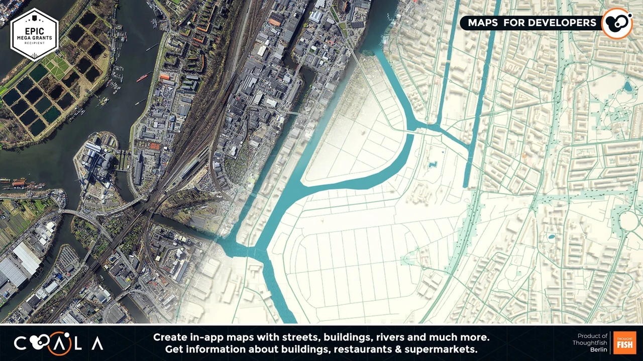
At the center of the plugin is the ability to generate in-app maps derived directly from physical earth data. Rather than building static city layouts by hand, the system reads geographical information to generate streets, rivers, and building footprints inside the runtime environment. These elements form a coherent spatial foundation that can be used for spatial navigation, urban exploration, or tactical gameplay scenarios set within recognizable real-world cities.
Beyond broad architectural and municipal geometry, the mapping pipeline retrieves detailed contextual attributes about specific structures. It provides specific information about buildings, supermarkets, and restaurants. This layer of detail transforms a hollow exterior mesh into an identifiable location, giving projects the ability to acknowledge commercial hubs, public facilities, and community infrastructure directly within the interactive space.
To support programmatic interactions across these geographic layouts, COALA enables creators to set up both static and dynamic Points of Interest (POIs). A static POI can mark an established architectural landmark, a specific supermarket, or a designated transit hub. Dynamic POIs allow creators to move markers, generate temporary objectives, or adapt target locations on the fly. By pairing point-of-interest systems with the underlying street and river vectors, interactive applications can build routing mechanics, quest markers, or geo-referenced information panels that correspond directly to physical coordinates.
Synchronizing Environmental States: Grid Terrains, Skybox Weather, and Moon Phases
Handling geography requires addressing the landmass beneath the architecture. The plugin handles elevation and ground generation by defining terrains on a grid basis. Dividing ground construction into grid structures allows for structured spatial generation, keeping the base surface predictable while aligning with the incoming coordinate bounds. This grid structure coordinates with imported roads and water bodies, establishing a solid ground plane for buildings, roadways, and navigational elements.
Visual context extends beyond the ground plane into the atmosphere. COALA links global temporal and atmospheric data directly to a reactive skybox. Instead of relying on static art assets or arbitrary daylight rotations, the skybox can access and display real-world weather conditions. If an area is undergoing overcast skies, rainfall, or clear conditions, the atmospheric visuals can match those live states.
Along with weather, the system calculates and matches real-world time and lunar cycles. Moon phases are tied directly to physical dates and coordinates, allowing nighttime scenes to accurately reflect the true lunar progression observed from that spot on Earth. Synchronizing location, atmospheric weather, and celestial states creates environments that stay faithful to the instantaneous conditions of the physical world.
GPS Mapping, Context-Aware Data, and Specialized Crime Data Feeds
Real-world integration often depends on live tracking, and COALA includes dedicated GPS mapping tools to handle position-aware interactions. Whether a project relies on active user positioning or tracks external sensor coordinates, the plugin provides the baseline tools needed to locate and anchor digital entities across the globe. This facilitates the production of mobile location utilities, vehicle tracking views, and territory-driven user mechanics.
The range of contextual data available through the system stretches past standard mapping geometry and meteorological statistics. The framework accommodates diverse datasets, extending from fundamental geolocation and timestamp tracking up to specialized crime data feeds. Incorporating safety and incident statistics allows specialized software—such as urban planning utilities, security assessment visualizations, or narrative-driven location simulations—to factor neighborhood metrics into runtime behavior.
Managing real-time geospatial feeds, atmospheric variables, and statistical feeds naturally introduces network overhead. The plugin is structured through responsible data rate consumption, keeping query volumes controlled so that data retrieval remains stable without placing unsustainable demands on network bandwidth or client performance.
The Premade Paper Map Project, Sci-Fi Styling, and Backend Integration
To assist with the initial implementation, the plugin includes a fully functioning, premade project titled "Paper Map." This sample setup serves as an operational reference, demonstrating how mapping structures, geometry generation, and geographic requests link together inside the engine. The Paper Map project is inherently constrained by server request limits, making it suitable for evaluating pipeline architecture, testing logic flows, and verifying local interactions before scaling up.
Operating beyond the baseline testing threshold requires transitioning to a dedicated backend setup. The plugin requires an active COALA account, which operates under a subscription model. Every newly registered project starts on a Free plan, which can subsequently be upgraded through its Configuration page as data demands increase. Establishing a custom project within the COALA backend removes the request restrictions present on the premade Paper Map demo, opening unrestricted access to the complete range of server functions, data streams, and mapping calls.
From an aesthetic perspective, the plugin can interface with dedicated style sets, such as the COALA - Real World Map Style "Sci-Fi" package. This stylistic compatibility allows developers to transform standard road networks and municipal boundaries into stylized, futuristic displays while retaining real-world coordinate fidelity. Regarding geographic availability, COALA services are currently not available for use in Russia.
Who Benefits Most From the COALA Architecture
This toolset directly serves technical teams and creators building software reliant on true geographic coordinates and live planetary information. Developers crafting location-based mobile games, real-time logistics displays, municipal planning applications, or augmented urban exploration tools can avoid building proprietary geocoding parsers and atmospheric polling systems. By unifying real-time weather, grid terrains, municipal data, and GPS utilities into a managed runtime pipeline, the system allows studios to focus entirely on interactive design, context-driven logic, and presentation.
 Engine Tools
 Engine Tools
 Engine Tools
 Engine Tools